
 Mikhaylovka
Dyrestuy
Mikhaylovka
Mayskiy
Novobessergenevka
Tersky District
Lesnoy
Tertezh
Kuz'minskiye Otverzhki
Mikhaylovka
Dyrestuy
Mikhaylovka
Mayskiy
Novobessergenevka
Tersky District
Lesnoy
Tertezh
Kuz'minskiye Otverzhki
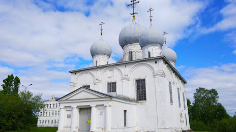
Spaso-Preobrazhenskiy Sobor on the map, Belozersk, Russian Federation
Photo
Where is located Spaso-Preobrazhenskiy Sobor
Spaso-Preobrazhenskiy Sobor — local attraction, which is located at Sovetskiy Prospekt, 8, Belozersk, Vologda Oblast, 161201 and belongs to the category — museum. Average visitor rating for this place — 4.7 (according to 24 ratings, information from open sources and relevant for 2022).
Exact location — Spaso-Preobrazhenskiy Sobor, marked on the map with a red marker.
You can get directions to Spaso-Preobrazhenskiy Sobor on the map from your location.
What else is interesting in Belozersk? You can see all the sights if you go to the city page.
Coordinates
Spaso-Preobrazhenskiy Sobor, Russian Federation coordinates in decimal format: latitude — 60.031570785433935, longitude — 37.78456609846729. When converted to degrees, minutes, seconds Spaso-Preobrazhenskiy Sobor has the following coordinates: 60°1′53.65 north latitude and 37°47′4.44 east longitude.
Nearby cities
The largest cities that are located nearby:
- Cherepovets — 100 km
- Vologda — 151 km
- Rybinsk — 228 km
- Petrozavodsk — 264 km
- Yaroslavl — 294 km
- Kostroma — 313 km
- Tver — 368 km
- Kolpino — 401 km
- Saint Petersburg — 412 km
- Pushkino — 446 km
- Zelenograd — 448 km
- Khimki — 458 km
- Vladimir — 460 km
- Kovrov — 460 km
- Noginsk — 462 km
- Balashikha — 466 km
- Elektrostal — 472 km
- Orekhovo-Zuyevo — 474 km
- Lyubertsy — 481 km
Distance to the capital
Distance to the capital (Moscow) is about — 476 km.