
 Mikhaylovka
Dyrestuy
Mikhaylovka
Mayskiy
Novobessergenevka
Tersky District
Lesnoy
Tertezh
Kuz'minskiye Otverzhki
Mikhaylovka
Dyrestuy
Mikhaylovka
Mayskiy
Novobessergenevka
Tersky District
Lesnoy
Tertezh
Kuz'minskiye Otverzhki
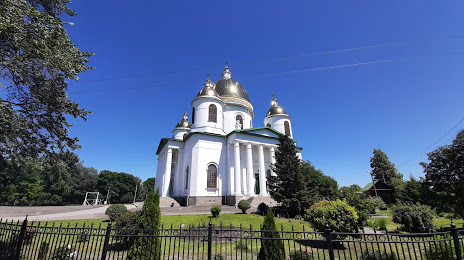
Svyato-Troitskiy Sobor on the map, Morshansk, Russian Federation
Photo
Where is located Svyato-Troitskiy Sobor
Svyato-Troitskiy Sobor — local attraction, which is located at Ulitsa Krasnaya, Morshansk, Tambov Oblast, 393950 and belongs to the category — russian orthodox church. Average visitor rating for this place — 4.9 (according to 82 ratings, information from open sources and relevant for 2022).
Exact location — Svyato-Troitskiy Sobor, marked on the map with a red marker.
You can get directions to Svyato-Troitskiy Sobor on the map from your location.
What else is interesting in Morshansk? You can see all the sights if you go to the city page.
Coordinates
Svyato-Troitskiy Sobor, Russian Federation coordinates in decimal format: latitude — 53.442272327799984, longitude — 41.82337169820856. When converted to degrees, minutes, seconds Svyato-Troitskiy Sobor has the following coordinates: 53°26′32.18 north latitude and 41°49′24.14 east longitude.
Nearby cities
The largest cities that are located nearby:
- Tambov — 85 km
- Lipetsk — 175 km
- Ryazan — 186 km
- Penza — 214 km
- Saransk — 232 km
- Murom — 235 km
- Novomoskovsk — 237 km
- Yelets — 241 km
- Arzamas — 250 km
- Voronezh — 265 km
- Kolomna — 265 km
- Tula — 284 km
- Vladimir — 311 km
- Orekhovo-Zuyevo — 315 km
- Serpukhov — 323 km
- Dzerzhinsk — 324 km
- Kovrov — 324 km
- Elektrostal — 332 km
- Noginsk — 340 km
Distance to the capital
Distance to the capital (Moscow) is about — 374 km.