
 Mikhaylovka
Dyrestuy
Mikhaylovka
Mayskiy
Novobessergenevka
Tersky District
Lesnoy
Tertezh
Kuz'minskiye Otverzhki
Mikhaylovka
Dyrestuy
Mikhaylovka
Mayskiy
Novobessergenevka
Tersky District
Lesnoy
Tertezh
Kuz'minskiye Otverzhki
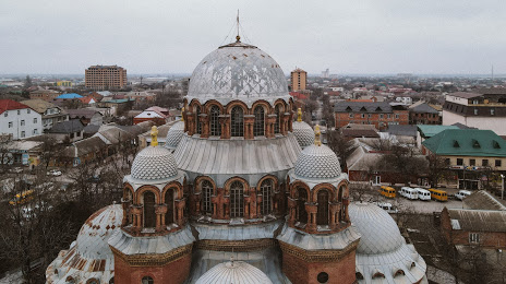
Znamenskiy Sobor on the map, Khasavyurt, Russian Federation
Photo
Where is located Znamenskiy Sobor
Znamenskiy Sobor — local attraction, which is located at Ulitsa Toturbiyeva, 121, Khasavyurt, Republic of Dagestan, 368000 and belongs to the category — church. Average visitor rating for this place — 4.2 (according to 146 ratings, information from open sources and relevant for 2022).
Exact location — Znamenskiy Sobor, marked on the map with a red marker.
You can get directions to Znamenskiy Sobor on the map from your location.
What else is interesting in Khasavyurt? You can see all the sights if you go to the city page.
Coordinates
Znamenskiy Sobor, Russian Federation coordinates in decimal format: latitude — 43.24523830323241, longitude — 46.58099959785111. When converted to degrees, minutes, seconds Znamenskiy Sobor has the following coordinates: 43°14′42.86 north latitude and 46°34′51.6 east longitude.
Nearby cities
The largest cities that are located nearby:
- Makhachkala — 81 km
- Nazran — 146 km
- Vladikavkaz — 158 km
- Derbent — 194 km
- Tbilisi
 (Georgia) — 225 km
 - Nalchik — 239 km
- Pyatigorsk — 294 km
- Kislovodsk — 317 km
- Vanadzor
 (Armenia) — 322 km
 - Kutaisi (Georgia) — 337 km
- Gyumri (Armenia) — 355 km
- Astrakhan — 362 km
- Aktau
 (Kazakhstan) — 372 km
 - Cherkessk — 375 km
- Yerevan (Armenia) — 381 km
- Elista — 382 km
- Nevinnomyssk — 397 km
- Stavropol — 411 km
- Parsabad
 (Iran) — 414 km
Distance to the capital
Distance to the capital (Moscow) is about — 1532 km.