
 Mikhaylovka
Dyrestuy
Mikhaylovka
Mayskiy
Novobessergenevka
Tersky District
Lesnoy
Tertezh
Kuz'minskiye Otverzhki
Mikhaylovka
Dyrestuy
Mikhaylovka
Mayskiy
Novobessergenevka
Tersky District
Lesnoy
Tertezh
Kuz'minskiye Otverzhki
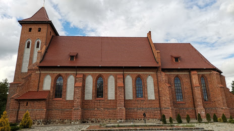
Kirkha Arnau, Monastyr' Svyatoy Yekateriny V Rodnikakh on the map, Guryevsk, Russian Federation
Photo
Where is located Kirkha Arnau, Monastyr' Svyatoy Yekateriny V Rodnikakh
Kirkha Arnau, Monastyr' Svyatoy Yekateriny V Rodnikakh — local attraction, which is located at Церковный переулок, 1, Rodniki, Kaliningrad Oblast, 238312 and belongs to the category — church. Average visitor rating for this place — 4.7 (according to 186 ratings, information from open sources and relevant for 2022).
Exact location — Kirkha Arnau, Monastyr' Svyatoy Yekateriny V Rodnikakh, marked on the map with a red marker.
You can get directions to Kirkha Arnau, Monastyr' Svyatoy Yekateriny V Rodnikakh on the map from your location.
What else is interesting in Guryevsk? You can see all the sights if you go to the city page.
Coordinates
Kirkha Arnau, Monastyr' Svyatoy Yekateriny V Rodnikakh, Russian Federation coordinates in decimal format: latitude — 54.700625382076815, longitude — 20.667279798256413. When converted to degrees, minutes, seconds Kirkha Arnau, Monastyr' Svyatoy Yekateriny V Rodnikakh has the following coordinates: 54°42′2.25 north latitude and 20°40′2.21 east longitude.
Nearby cities
The largest cities that are located nearby:
- Kaliningrad — 10 km
- Elblag
 (Poland) — 105 km
 - Klaipėda
 (Lithuania) — 107 km
 - Olsztyn (Poland) — 111 km
- Gdańsk (Poland) — 136 km
- Gdynia (Poland) — 137 km
- Kaunas (Lithuania) — 209 km
- Šiauliai (Lithuania) — 210 km
- Torun (Poland) — 237 km
- Bialystok (Poland) — 249 km
- Bydgoszcz (Poland) — 252 km
- Plock (Poland) — 255 km
- Panevėžys (Lithuania) — 256 km
- Wloclawek (Poland) — 258 km
- Warsaw (Poland) — 284 km
- Koszalin (Poland) — 295 km
- Vilnius (Lithuania) — 298 km
- Rīga
 (Latvia) — 319 km
 - Łódź (Poland) — 344 km
Distance to the capital
Distance to the capital (Moscow) is about — 1079 km.