
 Mikhaylovka
Dyrestuy
Mikhaylovka
Mayskiy
Novobessergenevka
Tersky District
Lesnoy
Tertezh
Kuz'minskiye Otverzhki
Mikhaylovka
Dyrestuy
Mikhaylovka
Mayskiy
Novobessergenevka
Tersky District
Lesnoy
Tertezh
Kuz'minskiye Otverzhki
Kandry-Kul' on the map, Kandry, Russian Federation
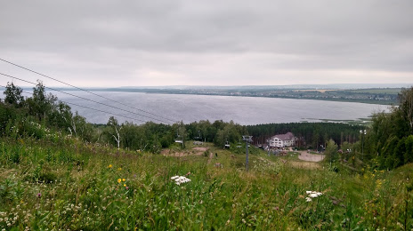
Photo
Where is located Kandry-Kul'
Kandry-Kul' — local attraction, which is located at д. Кандры-Кутуй, Republic of Bashkortostan, 452794 and belongs to the category — ski resort. Average visitor rating for this place — 4.6 (according to 229 ratings, information from open sources and relevant for 2022).
Exact location — Kandry-Kul', marked on the map with a red marker.
You can get directions to Kandry-Kul' on the map from your location.
What else is interesting in Kandry? You can see all the sights if you go to the city page.
Coordinates
Kandry-Kul', Russian Federation coordinates in decimal format: latitude — 54.50252699069706, longitude — 54.06388889878273. When converted to degrees, minutes, seconds Kandry-Kul' has the following coordinates: 54°30′9.1 north latitude and 54°3′50 east longitude.
Nearby cities
The largest cities that are located nearby:
- Almetyevsk — 120 km
- Ufa — 121 km
- Sterlitamak — 158 km
- Neftekamsk — 171 km
- Salavat — 178 km
- Nizhnekamsk — 186 km
- Sarapul — 212 km
- Izhevsk — 258 km
- Dimitrovgrad — 296 km
- Samara — 302 km
- Orenburg — 316 km
- Novokuybyshevsk — 320 km
- Tolyatti — 329 km
- Kazan — 338 km
- Magnitogorsk — 346 km
- Zlatoust — 358 km
- Ulyanovsk — 371 km
- Zelenodolsk — 375 km
- Miass — 383 km
Distance to the capital
Distance to the capital (Moscow) is about — 1053 km.