
 Mikhaylovka
Dyrestuy
Mikhaylovka
Mayskiy
Novobessergenevka
Tersky District
Lesnoy
Tertezh
Kuz'minskiye Otverzhki
Mikhaylovka
Dyrestuy
Mikhaylovka
Mayskiy
Novobessergenevka
Tersky District
Lesnoy
Tertezh
Kuz'minskiye Otverzhki
Krayevedcheskiy Muzey on the map, Chernyanka, Russian Federation
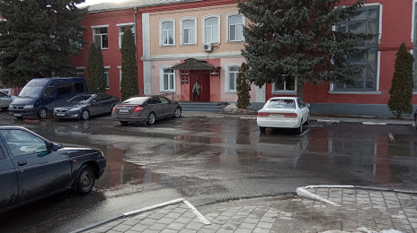
Photo
Where is located Krayevedcheskiy Muzey
Krayevedcheskiy Muzey — local attraction, which is located at Oktyabr'skaya Ploshchad', 8, Chernyanka, Belgorod Oblast, 309560 and belongs to the category — museum. Average visitor rating for this place — 4.6 (according to 9 ratings, information from open sources and relevant for 2022).
Exact location — Krayevedcheskiy Muzey, marked on the map with a red marker.
You can get directions to Krayevedcheskiy Muzey on the map from your location.
What else is interesting in Chernyanka? You can see all the sights if you go to the city page.
Coordinates
Krayevedcheskiy Muzey, Russian Federation coordinates in decimal format: latitude — 50.942708878513734, longitude — 37.80380739811578. When converted to degrees, minutes, seconds Krayevedcheskiy Muzey has the following coordinates: 50°56′33.75 north latitude and 37°48′13.71 east longitude.
Nearby cities
The largest cities that are located nearby:
- Belgorod — 92 km
- Voronezh — 127 km
- Kursk — 142 km
- Yelets — 192 km
- Sumy
 (Ukraine) — 209 km
 - Lipetsk — 221 km
- Poltava (Ukraine) — 276 km
- Alchevs'k
 — 281 km
 - Luhansk — 283 km
- Horlivka — 291 km
- Pavlohrad (Ukraine) — 302 km
- Tambov — 313 km
- Donetsk — 323 km
- Bryansk — 341 km
- Novomoskovsk — 342 km
- Dniprodzerzhyns'k (Ukraine) — 354 km
- Tula — 362 km
- Kremenchuk (Ukraine) — 379 km
- Shakhty — 401 km
Distance to the capital
Distance to the capital (Moscow) is about — 535 km.