
 Mikhaylovka
Dyrestuy
Mikhaylovka
Mayskiy
Novobessergenevka
Tersky District
Lesnoy
Tertezh
Kuz'minskiye Otverzhki
Mikhaylovka
Dyrestuy
Mikhaylovka
Mayskiy
Novobessergenevka
Tersky District
Lesnoy
Tertezh
Kuz'minskiye Otverzhki
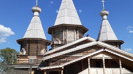
Mbu Kemskiy Muzey, Pomor'ye on the map, Kem, Russian Federation
Photo
Where is located Mbu Kemskiy Muzey, Pomor'ye
Mbu Kemskiy Muzey, Pomor'ye — local attraction, which is located at Ulitsa Vitsupa, 12а, Kem, Republic of Karelia, 186610 and belongs to the category — museum. Average visitor rating for this place — 4.6 (according to 52 ratings, information from open sources and relevant for 2022).
Exact location — Mbu Kemskiy Muzey, Pomor'ye, marked on the map with a red marker.
You can get directions to Mbu Kemskiy Muzey, Pomor'ye on the map from your location.
What else is interesting in Kem? You can see all the sights if you go to the city page.
Coordinates
Mbu Kemskiy Muzey, Pomor'ye, Russian Federation coordinates in decimal format: latitude — 64.94692846793939, longitude — 34.61613649867197. When converted to degrees, minutes, seconds Mbu Kemskiy Muzey, Pomor'ye has the following coordinates: 64°56′48.94 north latitude and 34°36′58.09 east longitude.
Nearby cities
The largest cities that are located nearby:
- Severodvinsk — 254 km
- Arkhangelsk — 288 km
- Petrozavodsk — 350 km
- Oulu
 (Finland) — 426 km
 - Saint Petersburg — 602 km
- Kolpino — 618 km
- Cherepovets — 670 km
- Tampere (Finland) — 687 km
- Vologda — 701 km
- Vantaa (Finland) — 734 km
- Helsinki (Finland) — 748 km
- Espoo (Finland) — 757 km
- Rybinsk — 802 km
- Tallinn
 (Estonia) — 823 km
 - Turku (Finland) — 836 km
- Tartu (Estonia) — 858 km
- Yaroslavl — 868 km
- Pskov — 870 km
- Kostroma — 878 km
Distance to the capital
Distance to the capital (Moscow) is about — 1035 km.