
 Mikhaylovka
Dyrestuy
Mikhaylovka
Mayskiy
Novobessergenevka
Tersky District
Lesnoy
Tertezh
Kuz'minskiye Otverzhki
Mikhaylovka
Dyrestuy
Mikhaylovka
Mayskiy
Novobessergenevka
Tersky District
Lesnoy
Tertezh
Kuz'minskiye Otverzhki
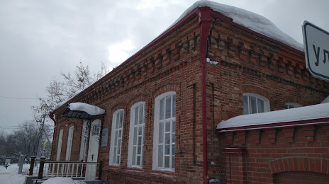
"Sverdlovskiy Oblastnoy Krayevedcheskiy Muzey Im. O.ye.klera" "Muzey - Napol'naya Shkola" on the map, Alapayevsk, Russian Federation
Photo
Where is located "Sverdlovskiy Oblastnoy Krayevedcheskiy Muzey Im. O.ye.klera" "Muzey - Napol'naya Shkola"
"Sverdlovskiy Oblastnoy Krayevedcheskiy Muzey Im. O.ye.klera" "Muzey - Napol'naya Shkola" — local attraction, which is located at Ulitsa Perminova, 58, Alapayevsk, Sverdlovsk Oblast, 624601 and belongs to the category — museum. Average visitor rating for this place — 5.0 (according to 1 rating, information from open sources and relevant for 2022).
Exact location — "Sverdlovskiy Oblastnoy Krayevedcheskiy Muzey Im. O.ye.klera" "Muzey - Napol'naya Shkola", marked on the map with a red marker.
You can get directions to "Sverdlovskiy Oblastnoy Krayevedcheskiy Muzey Im. O.ye.klera" "Muzey - Napol'naya Shkola" on the map from your location.
What else is interesting in Alapayevsk? You can see all the sights if you go to the city page.
Coordinates
"Sverdlovskiy Oblastnoy Krayevedcheskiy Muzey Im. O.ye.klera" "Muzey - Napol'naya Shkola", Russian Federation coordinates in decimal format: latitude — 57.866090447851846, longitude — 61.703383598380164. When converted to degrees, minutes, seconds "Sverdlovskiy Oblastnoy Krayevedcheskiy Muzey Im. O.ye.klera" "Muzey - Napol'naya Shkola" has the following coordinates: 57°51′57.93 north latitude and 61°42′12.18 east longitude.
Nearby cities
The largest cities that are located nearby:
- Yekaterinburg — 130 km
- Pervouralsk — 148 km
- Tyumen — 242 km
- Chelyabinsk — 297 km
- Perm — 316 km
- Zlatoust — 323 km
- Berezniki — 326 km
- Miass — 331 km
- Solikamsk — 340 km
- Kurgan — 349 km
- Neftekamsk — 496 km
- Ufa — 502 km
- Sarapul — 506 km
- Magnitogorsk — 522 km
- Izhevsk — 527 km
- Kostanay
 (Kazakhstan) — 528 km
 - Glazov — 528 km
- Sterlitamak — 600 km
- Salavat — 625 km
Distance to the capital
Distance to the capital (Moscow) is about — 1477 km.