
 Mikhaylovka
Dyrestuy
Mikhaylovka
Mayskiy
Novobessergenevka
Tersky District
Lesnoy
Tertezh
Kuz'minskiye Otverzhki
Mikhaylovka
Dyrestuy
Mikhaylovka
Mayskiy
Novobessergenevka
Tersky District
Lesnoy
Tertezh
Kuz'minskiye Otverzhki
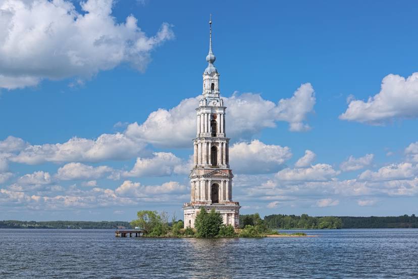
Kalyazinskaya Kolokol'nya on the map, Kalyazin, Russian Federation
Photo
Where is located Kalyazinskaya Kolokol'nya
Kalyazinskaya Kolokol'nya — local attraction, which is located at Tver Oblast, 171573 and belongs to the category — campanile. Average visitor rating for this place — 4.8 (according to 2024 ratings, information from open sources and relevant for 2022).
Exact location — Kalyazinskaya Kolokol'nya, marked on the map with a red marker.
You can get directions to Kalyazinskaya Kolokol'nya on the map from your location.
What else is interesting in Kalyazin? You can see all the sights if you go to the city page.
Coordinates
Kalyazinskaya Kolokol'nya, Russian Federation coordinates in decimal format: latitude — 57.24389885605415, longitude — 37.85679339835546. When converted to degrees, minutes, seconds Kalyazinskaya Kolokol'nya has the following coordinates: 57°14′38.04 north latitude and 37°51′24.46 east longitude.
Nearby cities
The largest cities that are located nearby:
- Rybinsk — 107 km
- Tver — 123 km
- Yaroslavl — 128 km
- Pushkino — 137 km
- Zelenograd — 143 km
- Khimki — 150 km
- Noginsk — 155 km
- Balashikha — 157 km
- Elektrostal — 165 km
- Lyubertsy — 171 km
- Orekhovo-Zuyevo — 174 km
- Odintsovo — 177 km
- Izmaylovo — 185 km
- Kostroma — 192 km
- Vladimir — 199 km
- Podolsk — 200 km
- Cherepovets — 210 km
- Kovrov — 235 km
- Kolomna — 244 km
Distance to the capital
Distance to the capital (Moscow) is about — 166 km.