
 Mikhaylovka
Dyrestuy
Mikhaylovka
Mayskiy
Novobessergenevka
Tersky District
Lesnoy
Tertezh
Kuz'minskiye Otverzhki
Mikhaylovka
Dyrestuy
Mikhaylovka
Mayskiy
Novobessergenevka
Tersky District
Lesnoy
Tertezh
Kuz'minskiye Otverzhki
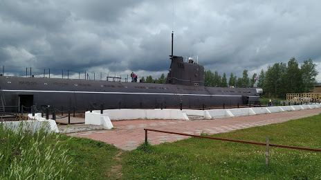
Muzej «Podvodnaya lodka B-440» on the map, Vytegra, Russian Federation
Photo
Where is located Muzej «Podvodnaya lodka B-440»
Muzej «Podvodnaya lodka B-440» — local attraction, which is located at Ulitsa Komsomol'skaya, 15, Vytegra, Vologda Oblast, 162953 and belongs to the category — museum. Average visitor rating for this place — 4.7 (according to 776 ratings, information from open sources and relevant for 2022).
Exact location — Muzej «Podvodnaya lodka B-440», marked on the map with a red marker.
You can get directions to Muzej «Podvodnaya lodka B-440» on the map from your location.
What else is interesting in Vytegra? You can see all the sights if you go to the city page.
Coordinates
Muzej «Podvodnaya lodka B-440», Russian Federation coordinates in decimal format: latitude — 60.998417473774246, longitude — 36.433892098506824. When converted to degrees, minutes, seconds Muzej «Podvodnaya lodka B-440» has the following coordinates: 60°59′54.3 north latitude and 36°26′2.01 east longitude.
Nearby cities
The largest cities that are located nearby:
- Petrozavodsk — 139 km
- Cherepovets — 224 km
- Vologda — 278 km
- Kolpino — 354 km
- Rybinsk — 356 km
- Saint Petersburg — 358 km
- Severodvinsk — 426 km
- Yaroslavl — 426 km
- Arkhangelsk — 438 km
- Kostroma — 446 km
- Tver — 460 km
- Zelenograd — 556 km
- Pushkino — 560 km
- Khimki — 569 km
- Noginsk — 581 km
- Balashikha — 582 km
- Vladimir — 591 km
- Elektrostal — 591 km
- Odintsovo — 593 km
Distance to the capital
Distance to the capital (Moscow) is about — 587 km.