
 Mikhaylovka
Dyrestuy
Mikhaylovka
Mayskiy
Novobessergenevka
Tersky District
Lesnoy
Tertezh
Kuz'minskiye Otverzhki
Mikhaylovka
Dyrestuy
Mikhaylovka
Mayskiy
Novobessergenevka
Tersky District
Lesnoy
Tertezh
Kuz'minskiye Otverzhki
Ozero Shekulduk on the map, Kulunda, Russian Federation
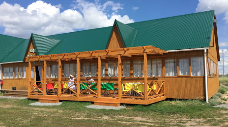
Photo
Where is located Ozero Shekulduk
Ozero Shekulduk — local attraction, which is located at no data and belongs to the category — -. Average visitor rating for this place — 4.3 (according to 20 ratings, information from open sources and relevant for 2022).
Exact location — Ozero Shekulduk, marked on the map with a red marker.
You can get directions to Ozero Shekulduk on the map from your location.
What else is interesting in Kulunda? You can see all the sights if you go to the city page.
Coordinates
Ozero Shekulduk, Russian Federation coordinates in decimal format: latitude — 52.53082914832772, longitude — 78.87637882997178. When converted to degrees, minutes, seconds Ozero Shekulduk has the following coordinates: 52°31′50.98 north latitude and 78°52′34.96 east longitude.
Nearby cities
The largest cities that are located nearby:
- Pavlodar
 (Kazakhstan) — 138 km
 - Rubtsovsk — 194 km
- Semey (Kazakhstan) — 254 km
- Ekibastuz (Kazakhstan) — 266 km
- Barnaul — 330 km
- Novosibirsk — 370 km
- Oskemen (Kazakhstan) — 387 km
- Biysk — 422 km
- Omsk — 444 km
- Temirtau (Kazakhstan) — 508 km
- Leninsk-Kuznetskiy — 516 km
- Prokopyevsk — 527 km
- Novokuznetsk — 550 km
- Tomsk — 570 km
- Seversk — 573 km
- Mezhdurechensk — 609 km
- Kokshetau (Kazakhstan) — 636 km
- Achinsk — 818 km
- Abakan — 826 km
Distance to the capital
Distance to the capital (Moscow) is about — 2671 km.