
 Mikhaylovka
Dyrestuy
Mikhaylovka
Mayskiy
Novobessergenevka
Tersky District
Lesnoy
Tertezh
Kuz'minskiye Otverzhki
Mikhaylovka
Dyrestuy
Mikhaylovka
Mayskiy
Novobessergenevka
Tersky District
Lesnoy
Tertezh
Kuz'minskiye Otverzhki
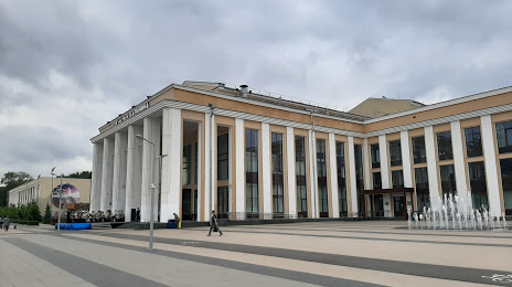
Centralnyj Dvorec Kultury imeni M.I.Kalinina on the map, Mytishchi, Russian Federation
Photo
Where is located Centralnyj Dvorec Kultury imeni M.I.Kalinina
Centralnyj Dvorec Kultury imeni M.I.Kalinina — local attraction, which is located at Ulitsa Tereshkovoy, 1, Korolyov, Moscow Oblast, 141070 and belongs to the category — cultural center. Average visitor rating for this place — 4.6 (according to 2046 ratings, information from open sources and relevant for 2022).
Exact location — Centralnyj Dvorec Kultury imeni M.I.Kalinina, marked on the map with a red marker.
You can get directions to Centralnyj Dvorec Kultury imeni M.I.Kalinina on the map from your location.
What else is interesting in Mytishchi? You can see all the sights if you go to the city page.
Coordinates
Centralnyj Dvorec Kultury imeni M.I.Kalinina, Russian Federation coordinates in decimal format: latitude — 55.91836561983111, longitude — 37.81421129830352. When converted to degrees, minutes, seconds Centralnyj Dvorec Kultury imeni M.I.Kalinina has the following coordinates: 55°55′6.12 north latitude and 37°48′51.16 east longitude.
Nearby cities
The largest cities that are located nearby:
- Pushkino — 10 km
- Balashikha — 17 km
- Khimki — 20 km
- Lyubertsy — 27 km
- Zelenograd — 37 km
- Izmaylovo — 40 km
- Odintsovo — 42 km
- Noginsk — 44 km
- Elektrostal — 46 km
- Podolsk — 56 km
- Orekhovo-Zuyevo — 76 km
- Kolomna — 111 km
- Serpukhov — 113 km
- Obninsk — 115 km
- Tver — 152 km
- Vladimir — 165 km
- Kaluga — 179 km
- Tula — 190 km
- Ryazan — 191 km
Distance to the capital
Distance to the capital (Moscow) is about — 22 km.