
 Mikhaylovka
Dyrestuy
Mikhaylovka
Mayskiy
Novobessergenevka
Tersky District
Lesnoy
Tertezh
Kuz'minskiye Otverzhki
Mikhaylovka
Dyrestuy
Mikhaylovka
Mayskiy
Novobessergenevka
Tersky District
Lesnoy
Tertezh
Kuz'minskiye Otverzhki
Tenginskiye Vodopady on the map, Novomikhaylovskiy, Russian Federation
Photo
Where is located Tenginskiye Vodopady
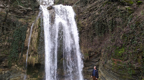
Tenginskiye Vodopady — local attraction, which is located at Unnamed Road, Krasnodar Krai, 352843 and belongs to the category — hiking area. Average visitor rating for this place — 4.0 (according to 80 ratings, information from open sources and relevant for 2022).
Exact location — Tenginskiye Vodopady, marked on the map with a red marker.
You can get directions to Tenginskiye Vodopady on the map from your location.
What else is interesting in Novomikhaylovskiy? You can see all the sights if you go to the city page.
Coordinates
Tenginskiye Vodopady, Russian Federation coordinates in decimal format: latitude — 44.33192706306597, longitude — 38.80364709224265. When converted to degrees, minutes, seconds Tenginskiye Vodopady has the following coordinates: 44°19′54.94 north latitude and 38°48′13.13 east longitude.
Nearby cities
The largest cities that are located nearby:
- Krasnodar — 87 km
- Novorossiysk — 100 km
- Sochi — 101 km
- Maykop — 105 km
- Kerch — 222 km
- Nevinnomyssk — 247 km
- Cherkessk — 254 km
- Stavropol — 261 km
- Kislovodsk — 311 km
- Berdyans'k
 — 319 km
 - Bataysk — 327 km
- Taganrog — 328 km
- Pyatigorsk — 335 km
- Novocherkassk — 362 km
- Trabzon
 (Turkey) — 366 km
 - Batumi
 (Georgia) — 369 km
 - Ordu (Turkey) — 370 km
- Simferopol — 379 km
- Kutaisi (Georgia) — 385 km
Distance to the capital
Distance to the capital (Moscow) is about — 1273 km.