
 Bokamoso
Buysdorp
Xihosana
Ga-Sekororo
Ga-Rankuwa
Three Sisters
George
Haenertsburg
Polokwane
Bokamoso
Buysdorp
Xihosana
Ga-Sekororo
Ga-Rankuwa
Three Sisters
George
Haenertsburg
Polokwane
Nahoon Point Lighthouse on the map, East London, South Africa
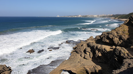
Photo
Where is located Nahoon Point Lighthouse
Nahoon Point Lighthouse — local attraction, which is located at 5241,, Stirling, East London, South Africa and belongs to the category — tourist attraction. Average visitor rating for this place — 4.3 (according to 44 ratings, information from open sources and relevant for 2022).
Exact location — Nahoon Point Lighthouse, marked on the map with a red marker.
You can get directions to Nahoon Point Lighthouse on the map from your location.
What else is interesting in East London? You can see all the sights if you go to the city page.
Coordinates
Nahoon Point Lighthouse, South Africa coordinates in decimal format: latitude — -32.997977724279394, longitude — 27.945058197712584. When converted to degrees, minutes, seconds Nahoon Point Lighthouse has the following coordinates: -32°59′52.72 north latitude and 27°56′42.21 east longitude.
Nearby cities
The largest cities that are located nearby:
- Bisho — 42 km
- Queenstown — 149 km
- Port Elizabeth — 234 km
- Uitenhage — 242 km
- Maseru
 (Lesotho) — 408 km
 - Botshabelo — 425 km
- Pietermaritzburg — 445 km
- Bloemfontein — 456 km
- Durban — 459 km
- George — 508 km
- Mossel Bay — 541 km
- Virginia — 548 km
- Kimberley — 557 km
- Welkom — 564 km
- Kroonstad — 593 km
- Newcastle — 614 km
- Richards Bay — 616 km
- Vryheid — 644 km
- Orkney — 674 km
Distance to the capital
Distance to the capital (Pretoria) is about — 807 km.