
 Bokamoso
Buysdorp
Xihosana
Ga-Sekororo
Ga-Rankuwa
Three Sisters
George
Haenertsburg
Polokwane
Bokamoso
Buysdorp
Xihosana
Ga-Sekororo
Ga-Rankuwa
Three Sisters
George
Haenertsburg
Polokwane
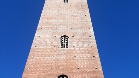
The Campanile on the map, Port Elizabeth, South Africa
Photo
Where is located The Campanile
The Campanile — local attraction, which is located at Strand St, Port Elizabeth Central, Gqeberha, 6001, South Africa and belongs to the category — historical landmark. Average visitor rating for this place — 4.3 (according to 179 ratings, information from open sources and relevant for 2022).
Exact location — The Campanile, marked on the map with a red marker.
You can get directions to The Campanile on the map from your location.
What else is interesting in Port Elizabeth? You can see all the sights if you go to the city page.
Coordinates
The Campanile, South Africa coordinates in decimal format: latitude — -33.96071196097207, longitude — 25.624950197737522. When converted to degrees, minutes, seconds The Campanile has the following coordinates: -33°57′38.56 north latitude and 25°37′29.82 east longitude.
Nearby cities
The largest cities that are located nearby:
- Uitenhage — 27 km
- Bisho — 210 km
- East London — 236 km
- Queenstown — 260 km
- George — 289 km
- Mossel Bay — 318 km
- Botshabelo — 530 km
- Bloemfontein — 539 km
- Maseru
 (Lesotho) — 545 km
 - Worcester — 568 km
- Kimberley — 582 km
- Paarl — 612 km
- Cape Town — 658 km
- Virginia — 658 km
- Pietermaritzburg — 666 km
- Welkom — 670 km
- Durban — 690 km
- Kroonstad — 716 km
- Orkney — 779 km
Distance to the capital
Distance to the capital (Pretoria) is about — 946 km.