
 زفتى
Qesm Hurghada
Gazirat Muhammad
Qesm Nakhl
Om Sabir Village
6th of October City
Cairo Governorate
Qism Sidi Gabir
Ezbet Hussein Salamah
زفتى
Qesm Hurghada
Gazirat Muhammad
Qesm Nakhl
Om Sabir Village
6th of October City
Cairo Governorate
Qism Sidi Gabir
Ezbet Hussein Salamah
St. Takla Church on the map, Alexandria, Egypt
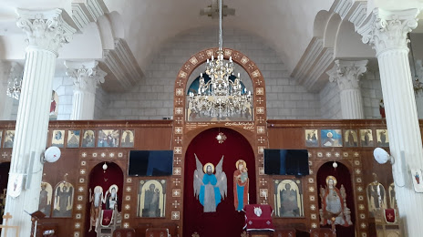
Photo
Where is located St. Takla Church
St. Takla Church — local attraction, which is located at 35 Mohammed Fouad Galal, Al Ibrahimeyah Qebli WA Al Hadrah Bahri, Qism Bab Sharqi, Alexandria Governorate, Egypt and belongs to the category — orthodox church. Average visitor rating for this place — 4.4 (according to 696 ratings, information from open sources and relevant for 2022).
Exact location — St. Takla Church, marked on the map with a red marker.
You can get directions to St. Takla Church on the map from your location.
What else is interesting in Alexandria? You can see all the sights if you go to the city page.
Coordinates
St. Takla Church, Egypt coordinates in decimal format: latitude — 31.2108273180082, longitude — 29.92633749766806. When converted to degrees, minutes, seconds St. Takla Church has the following coordinates: 31°12′38.98 north latitude and 29°55′34.81 east longitude.
Nearby cities
The largest cities that are located nearby:
- Idku — 38 km
- Talkha — 139 km
- Banha — 145 km
- Zagazig — 166 km
- Qalyub — 167 km
- Port Said — 225 km
- Ismailia — 234 km
- Beni Suef — 262 km
- Suez — 287 km
- Mallawi — 394 km
- Ashqelon
 (Israel) — 441 km
 - Ashdod (Israel) — 450 km
- Bat Yam (Israel) — 462 km
- Asyut — 462 km
- Tel Aviv-Yafo (Israel) — 466 km
- Ramat Gan (Israel) — 470 km
- Netanya (Israel) — 477 km
- Limassol
 (Cyprus) — 480 km
 - Jerusalem (Israel) — 502 km
Distance to the capital
Distance to the capital (Cairo) is about — 180 km.