
 Zelfana
Balloul
أحمد سالم كركرة
Ouargla Province
Boumaiza
Constantine
Frane
Ain Arko
Corso
Zelfana
Balloul
أحمد سالم كركرة
Ouargla Province
Boumaiza
Constantine
Frane
Ain Arko
Corso
Pont des Chutes on the map, Constantine, Algeria
Photo
Where is located Pont des Chutes
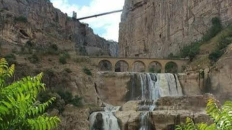
Pont des Chutes — local attraction, which is located at Boulevard Zighoud Youcef،, Constantine, Algeria and belongs to the category — bridge. Average visitor rating for this place — 4.8 (according to 4 ratings, information from open sources and relevant for 2022).
Exact location — Pont des Chutes, marked on the map with a red marker.
You can get directions to Pont des Chutes on the map from your location.
What else is interesting in Constantine? You can see all the sights if you go to the city page.
Coordinates
Pont des Chutes, Algeria coordinates in decimal format: latitude — 36.3732279861672, longitude — 6.611227197802832. When converted to degrees, minutes, seconds Pont des Chutes has the following coordinates: 36°22′23.62 north latitude and 6°36′40.42 east longitude.
Nearby cities
The largest cities that are located nearby:
- Skikda — 63 km
- Guelma — 75 km
- Batna — 97 km
- Setif — 107 km
- Annaba — 120 km
- Souk Ahras — 121 km
- Bejaia — 144 km
- Bou Arreridj Bordj — 168 km
- Tebessa — 172 km
- M'Sila — 199 km
- Bizerte
 (Tunisia) — 305 km
 - Sidi M'Hamed — 308 km
- Tunis (Tunisia) — 321 km
- El Oued — 330 km
- Médéa — 343 km
- Sousse (Tunisia) — 364 km
- Cagliari
 (Italy) — 384 km
 - Sfax (Tunisia) — 419 km
- Gabes (Tunisia) — 423 km