
 Zelfana
Balloul
أحمد سالم كركرة
Ouargla Province
Boumaiza
Constantine
Frane
Ain Arko
Corso
Zelfana
Balloul
أحمد سالم كركرة
Ouargla Province
Boumaiza
Constantine
Frane
Ain Arko
Corso
Plage Saint-Cloud on the map, Annaba, Algeria
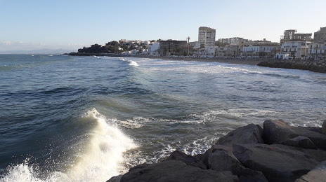
Photo
Where is located Plage Saint-Cloud
Plage Saint-Cloud — local attraction, which is located at no data and belongs to the category — -. Average visitor rating for this place — 4.2 (according to 130 ratings, information from open sources and relevant for 2022).
Exact location — Plage Saint-Cloud, marked on the map with a red marker.
You can get directions to Plage Saint-Cloud on the map from your location.
What else is interesting in Annaba? You can see all the sights if you go to the city page.
Coordinates
Plage Saint-Cloud, Algeria coordinates in decimal format: latitude — 36.91929325181174, longitude — 7.765941847818169. When converted to degrees, minutes, seconds Plage Saint-Cloud has the following coordinates: 36°55′9.46 north latitude and 7°45′57.39 east longitude.
Nearby cities
The largest cities that are located nearby:
- Guelma — 58 km
- Souk Ahras — 70 km
- Skikda — 77 km
- Constantine — 120 km
- Tebessa — 169 km
- Bizerte
 (Tunisia) — 189 km
 - Batna — 207 km
- Tunis (Tunisia) — 214 km
- Setif — 224 km
- Bejaia — 241 km
- Sousse (Tunisia) — 281 km
- Cagliari
 (Italy) — 282 km
 - Bou Arreridj Bordj — 284 km
- M'Sila — 320 km
- Sfax (Tunisia) — 363 km
- Gabes (Tunisia) — 397 km
- El Oued — 399 km
- Sidi M'Hamed — 409 km
- Sassari (Italy) — 428 km