
 Zelfana
Balloul
أحمد سالم كركرة
Ouargla Province
Boumaiza
Constantine
Frane
Ain Arko
Corso
Zelfana
Balloul
أحمد سالم كركرة
Ouargla Province
Boumaiza
Constantine
Frane
Ain Arko
Corso
Plage Djenen El Bey on the map, Annaba, Algeria
Photo
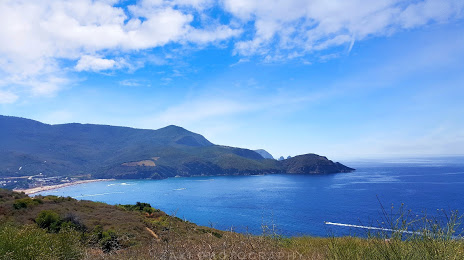
Where is located Plage Djenen El Bey
Plage Djenen El Bey — local attraction, which is located at no data and belongs to the category — -. Average visitor rating for this place — 4.5 (according to 229 ratings, information from open sources and relevant for 2022).
Exact location — Plage Djenen El Bey, marked on the map with a red marker.
You can get directions to Plage Djenen El Bey on the map from your location.
What else is interesting in Annaba? You can see all the sights if you go to the city page.
Coordinates
Plage Djenen El Bey, Algeria coordinates in decimal format: latitude — 36.950678347998306, longitude — 7.705079991338866. When converted to degrees, minutes, seconds Plage Djenen El Bey has the following coordinates: 36°57′2.44 north latitude and 7°42′18.29 east longitude.
Nearby cities
The largest cities that are located nearby:
- Guelma — 58 km
- Souk Ahras — 70 km
- Skikda — 77 km
- Constantine — 120 km
- Tebessa — 169 km
- Bizerte
 (Tunisia) — 189 km
 - Batna — 207 km
- Tunis (Tunisia) — 214 km
- Setif — 224 km
- Bejaia — 241 km
- Sousse (Tunisia) — 281 km
- Cagliari
 (Italy) — 282 km
 - Bou Arreridj Bordj — 284 km
- M'Sila — 320 km
- Sfax (Tunisia) — 363 km
- Gabes (Tunisia) — 397 km
- El Oued — 399 km
- Sidi M'Hamed — 409 km
- Sassari (Italy) — 428 km