
 Zelfana
Balloul
أحمد سالم كركرة
Ouargla Province
Boumaiza
Constantine
Frane
Ain Arko
Corso
Zelfana
Balloul
أحمد سالم كركرة
Ouargla Province
Boumaiza
Constantine
Frane
Ain Arko
Corso
Fort Musa on the map, Bejaia, Algeria
Photo
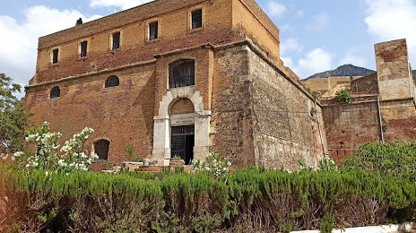
Where is located Fort Musa
Fort Musa — local attraction, which is located at Q34M+2GM, Béjaïa, Algeria and belongs to the category — historical place. Average visitor rating for this place — 4.1 (according to 35 ratings, information from open sources and relevant for 2022).
Exact location — Fort Musa, marked on the map with a red marker.
You can get directions to Fort Musa on the map from your location.
What else is interesting in Bejaia? You can see all the sights if you go to the city page.
Coordinates
Fort Musa, Algeria coordinates in decimal format: latitude — 36.75528688453802, longitude — 5.083794597813584. When converted to degrees, minutes, seconds Fort Musa has the following coordinates: 36°45′19.03 north latitude and 5°5′1.66 east longitude.
Nearby cities
The largest cities that are located nearby:
- Setif — 69 km
- Bou Arreridj Bordj — 80 km
- M'Sila — 127 km
- Constantine — 144 km
- Skikda — 164 km
- Batna — 166 km
- Sidi M'Hamed — 169 km
- Médéa — 212 km
- Guelma — 214 km
- Annaba — 240 km
- Souk Ahras — 263 km
- Tebessa — 314 km
- Chlef — 339 km
- Palma
 (Spain) — 373 km
 - Laghouat — 383 km
- El Oued — 409 km
- Relizane — 420 km
- Bizerte
 (Tunisia) — 427 km
 - Cagliari
 (Italy) — 443 km