 Pointe-à-la-Croix
Sainte-Irène, Quebec
Marsoui
Hecla
Muskrat Dam
Wunnummin Lake
Sainte-Brigitte-de-Laval
Drayton
Mauricie
Pointe-à-la-Croix
Sainte-Irène, Quebec
Marsoui
Hecla
Muskrat Dam
Wunnummin Lake
Sainte-Brigitte-de-Laval
Drayton
Mauricie
Sunridge Ski Area on the map, Edmonton, Canada
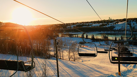
Photo
Where is located Sunridge Ski Area
Sunridge Ski Area — local attraction, which is located at 10980 17 St NW, Edmonton, AB T6S 1E4, Canada and belongs to the category — ski area. Average visitor rating for this place — 4.4 (according to 446 ratings, information from open sources and relevant for 2022).
Exact location — Sunridge Ski Area, marked on the map with a red marker.
You can get directions to Sunridge Ski Area on the map from your location.
What else is interesting in Edmonton? You can see all the sights if you go to the city page.
Coordinates
Sunridge Ski Area, Canada coordinates in decimal format: latitude — 53.56445402346672, longitude — -113.37079890162843. When converted to degrees, minutes, seconds Sunridge Ski Area has the following coordinates: 53°33′52.03 north latitude and -113°22′14.88 east longitude.
Nearby cities
The largest cities that are located nearby:
- Calgary — 279 km
- Saskatoon — 489 km
- Kelowna — 589 km
- Regina — 713 km
- Spokane
 (United States) — 714 km
 - Abbotsford — 810 km
- Coquitlam — 820 km
- Anmore — 821 km
- Surrey — 831 km
- Burnaby — 831 km
- Vancouver — 839 km
- Delta — 848 km
- Richmond — 849 km
- Victoria — 919 km
- Bellevue (United States) — 923 km
- Seattle (United States) — 930 km
- Tacoma (United States) — 967 km
- Boise (United States) — 1119 km
- Portland (United States) — 1137 km
Distance to the capital
Distance to the capital (Ottawa) is about — 2830 km.