 Pointe-à-la-Croix
Sainte-Irène, Quebec
Marsoui
Hecla
Muskrat Dam
Wunnummin Lake
Sainte-Brigitte-de-Laval
Drayton
Mauricie
Pointe-à-la-Croix
Sainte-Irène, Quebec
Marsoui
Hecla
Muskrat Dam
Wunnummin Lake
Sainte-Brigitte-de-Laval
Drayton
Mauricie
Centre PHI on the map, Montreal, Canada
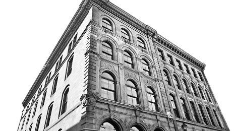
Photo
Where is located Centre PHI
Centre PHI — local attraction, which is located at 315 Saint-Paul St W, Montreal, Quebec H2Y 2M3, Canada and belongs to the category — art center. Average visitor rating for this place — 4.6 (according to 384 ratings, information from open sources and relevant for 2022).
Exact location — Centre PHI, marked on the map with a red marker.
You can get directions to Centre PHI on the map from your location.
What else is interesting in Montreal? You can see all the sights if you go to the city page.
Coordinates
Centre PHI, Canada coordinates in decimal format: latitude — 45.50211259134842, longitude — -73.55662965191637. When converted to degrees, minutes, seconds Centre PHI has the following coordinates: 45°30′7.61 north latitude and -73°33′23.87 east longitude.
Nearby cities
The largest cities that are located nearby:
- Longueuil — 6 km
- Laval — 16 km
- Trois-Rivières — 122 km
- Sherbrooke — 131 km
- Gatineau — 165 km
- Levis — 223 km
- Quebec — 227 km
- Kingston — 271 km
- Manchester
 (United States) — 326 km
 - Syracuse (United States) — 342 km
- Amherst (United States) — 360 km
- Lowell (United States) — 366 km
- Saguenay — 372 km
- Springfield (United States) — 384 km
- Worcester (United States) — 386 km
- Cambridge (United States) — 400 km
- Boston (United States) — 403 km
- Rochester (United States) — 416 km
- Hartford (United States) — 420 km
Distance to the capital
Distance to the capital (Ottawa) is about — 167 km.