 Pointe-à-la-Croix
Sainte-Irène, Quebec
Marsoui
Hecla
Muskrat Dam
Wunnummin Lake
Sainte-Brigitte-de-Laval
Drayton
Mauricie
Pointe-à-la-Croix
Sainte-Irène, Quebec
Marsoui
Hecla
Muskrat Dam
Wunnummin Lake
Sainte-Brigitte-de-Laval
Drayton
Mauricie
Jean-Doré Beach on the map, Montreal, Canada
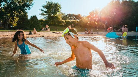
Photo
Where is located Jean-Doré Beach
Jean-Doré Beach — local attraction, which is located at 151 Circuit Gilles Villeneuve, Montréal, QC H3C 1A9, Canada and belongs to the category — tourist attraction. Average visitor rating for this place — 4.2 (according to 1033 ratings, information from open sources and relevant for 2022).
Exact location — Jean-Doré Beach, marked on the map with a red marker.
You can get directions to Jean-Doré Beach on the map from your location.
What else is interesting in Montreal? You can see all the sights if you go to the city page.
Coordinates
Jean-Doré Beach, Canada coordinates in decimal format: latitude — 45.49869780206613, longitude — -73.52293560191644. When converted to degrees, minutes, seconds Jean-Doré Beach has the following coordinates: 45°29′55.31 north latitude and -73°31′22.57 east longitude.
Nearby cities
The largest cities that are located nearby:
- Longueuil — 6 km
- Laval — 16 km
- Trois-Rivières — 122 km
- Sherbrooke — 131 km
- Gatineau — 165 km
- Levis — 223 km
- Quebec — 227 km
- Kingston — 271 km
- Manchester
 (United States) — 326 km
 - Syracuse (United States) — 342 km
- Amherst (United States) — 360 km
- Lowell (United States) — 366 km
- Saguenay — 372 km
- Springfield (United States) — 384 km
- Worcester (United States) — 386 km
- Cambridge (United States) — 400 km
- Boston (United States) — 403 km
- Rochester (United States) — 416 km
- Hartford (United States) — 420 km
Distance to the capital
Distance to the capital (Ottawa) is about — 170 km.