 Pointe-à-la-Croix
Sainte-Irène, Quebec
Marsoui
Hecla
Muskrat Dam
Wunnummin Lake
Sainte-Brigitte-de-Laval
Drayton
Mauricie
Pointe-à-la-Croix
Sainte-Irène, Quebec
Marsoui
Hecla
Muskrat Dam
Wunnummin Lake
Sainte-Brigitte-de-Laval
Drayton
Mauricie
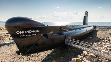
Sous-marin Onondaga - SHMP on the map, Rimouski, Canada
Photo
Where is located Sous-marin Onondaga - SHMP
Sous-marin Onondaga - SHMP — local attraction, which is located at 1000 Rue du Phare, Rimouski, QC G5M 1L8, Canada and belongs to the category — oberon-class submarine. Average visitor rating for this place — 4.7 (according to 549 ratings, information from open sources and relevant for 2022).
Exact location — Sous-marin Onondaga - SHMP, marked on the map with a red marker.
You can get directions to Sous-marin Onondaga - SHMP on the map from your location.
What else is interesting in Rimouski? You can see all the sights if you go to the city page.
Coordinates
Sous-marin Onondaga - SHMP, Canada coordinates in decimal format: latitude — 48.5174761867566, longitude — -68.4717540018127. When converted to degrees, minutes, seconds Sous-marin Onondaga - SHMP has the following coordinates: 48°31′2.91 north latitude and -68°28′18.31 east longitude.
Nearby cities
The largest cities that are located nearby:
- Saguenay — 187 km
- Quebec — 269 km
- Levis — 274 km
- Trois-Rivières — 380 km
- Sherbrooke — 420 km
- Longueuil — 498 km
- Montreal — 504 km
- Laval — 505 km
- Dartmouth — 566 km
- Halifax — 566 km
- Manchester
 (United States) — 640 km
 - Gatineau — 642 km
- Lowell (United States) — 674 km
- Cambridge (United States) — 696 km
- Boston (United States) — 696 km
- Worcester (United States) — 727 km
- Amherst (United States) — 742 km
- Providence (United States) — 762 km
- Springfield (United States) — 769 km
Distance to the capital
Distance to the capital (Ottawa) is about — 647 km.