 Pointe-à-la-Croix
Sainte-Irène, Quebec
Marsoui
Hecla
Muskrat Dam
Wunnummin Lake
Sainte-Brigitte-de-Laval
Drayton
Mauricie
Pointe-à-la-Croix
Sainte-Irène, Quebec
Marsoui
Hecla
Muskrat Dam
Wunnummin Lake
Sainte-Brigitte-de-Laval
Drayton
Mauricie
Burnaby Lake Regional Park on the map, Burnaby, Canada
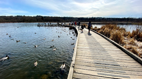
Photo
Where is located Burnaby Lake Regional Park
Burnaby Lake Regional Park — local attraction, which is located at 4519 Piper Ave, Burnaby, BC V5A 3B5, Canada and belongs to the category — park. Average visitor rating for this place — 4.5 (according to 2025 ratings, information from open sources and relevant for 2022).
Exact location — Burnaby Lake Regional Park, marked on the map with a red marker.
You can get directions to Burnaby Lake Regional Park on the map from your location.
What else is interesting in Burnaby? You can see all the sights if you go to the city page.
Coordinates
Burnaby Lake Regional Park, Canada coordinates in decimal format: latitude — 49.24606402967017, longitude — -122.93992471244714. When converted to degrees, minutes, seconds Burnaby Lake Regional Park has the following coordinates: 49°14′45.83 north latitude and -122°56′23.73 east longitude.
Nearby cities
The largest cities that are located nearby:
- Anmore — 10 km
- Vancouver — 11 km
- Surrey — 13 km
- Coquitlam — 13 km
- Richmond — 16 km
- Delta — 19 km
- Abbotsford — 52 km
- Victoria — 97 km
- Seattle
 (United States) — 190 km
 - Bellevue (United States) — 192 km
- Tacoma (United States) — 226 km
- Kelowna — 257 km
- Portland (United States) — 415 km
- Spokane (United States) — 449 km
- Salem (United States) — 478 km
- Eugene (United States) — 577 km
- Calgary — 649 km
- Edmonton — 782 km
- Boise (United States) — 826 km
Distance to the capital
Distance to the capital (Ottawa) is about — 3528 km.