 Pointe-à-la-Croix
Sainte-Irène, Quebec
Marsoui
Hecla
Muskrat Dam
Wunnummin Lake
Sainte-Brigitte-de-Laval
Drayton
Mauricie
Pointe-à-la-Croix
Sainte-Irène, Quebec
Marsoui
Hecla
Muskrat Dam
Wunnummin Lake
Sainte-Brigitte-de-Laval
Drayton
Mauricie
Rolling Green Fairways Golf Course and RV Park on the map, Lloydminster, Canada
Photo
Where is located Rolling Green Fairways Golf Course and RV Park
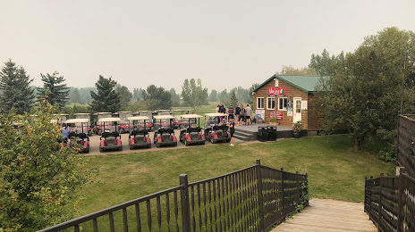
Rolling Green Fairways Golf Course and RV Park — local attraction, which is located at Box 11453, Range Rd 13, Lloydminster, AB T9V 3B7, Canada and belongs to the category — public golf course. Average visitor rating for this place — 4.5 (according to 115 ratings, information from open sources and relevant for 2022).
Exact location — Rolling Green Fairways Golf Course and RV Park, marked on the map with a red marker.
You can get directions to Rolling Green Fairways Golf Course and RV Park on the map from your location.
What else is interesting in Lloydminster? You can see all the sights if you go to the city page.
Coordinates
Rolling Green Fairways Golf Course and RV Park, Canada coordinates in decimal format: latitude — 53.28712270348144, longitude — -110.07592010163886. When converted to degrees, minutes, seconds Rolling Green Fairways Golf Course and RV Park has the following coordinates: 53°17′13.64 north latitude and -110°4′33.31 east longitude.
Nearby cities
The largest cities that are located nearby:
- Edmonton — 231 km
- Saskatoon — 259 km
- Calgary — 375 km
- Regina — 492 km
- Kelowna — 773 km
- Spokane
 (United States) — 831 km
 - Winnipeg — 990 km
- Abbotsford — 1008 km
- Coquitlam — 1023 km
- Anmore — 1025 km
- Surrey — 1033 km
- Burnaby — 1035 km
- Vancouver — 1044 km
- Delta — 1050 km
- Richmond — 1052 km
- Bellevue (United States) — 1104 km
- Seattle (United States) — 1112 km
- Victoria — 1117 km
- Tacoma (United States) — 1147 km
Distance to the capital
Distance to the capital (Ottawa) is about — 2610 km.