 Pointe-à-la-Croix
Sainte-Irène, Quebec
Marsoui
Hecla
Muskrat Dam
Wunnummin Lake
Sainte-Brigitte-de-Laval
Drayton
Mauricie
Pointe-à-la-Croix
Sainte-Irène, Quebec
Marsoui
Hecla
Muskrat Dam
Wunnummin Lake
Sainte-Brigitte-de-Laval
Drayton
Mauricie
Long Branch Park on the map, Mississauga, Canada
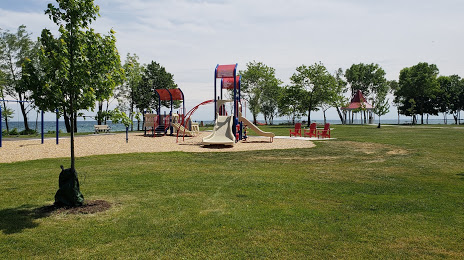
Photo
Where is located Long Branch Park
Long Branch Park — local attraction, which is located at 245 Lake Promenade, Etobicoke, ON M8W 1B3, Canada and belongs to the category — park. Average visitor rating for this place — 4.6 (according to 348 ratings, information from open sources and relevant for 2022).
Exact location — Long Branch Park, marked on the map with a red marker.
You can get directions to Long Branch Park on the map from your location.
What else is interesting in Mississauga? You can see all the sights if you go to the city page.
Coordinates
Long Branch Park, Canada coordinates in decimal format: latitude — 43.588817297076794, longitude — -79.52982520197943. When converted to degrees, minutes, seconds Long Branch Park has the following coordinates: 43°35′19.74 north latitude and -79°31′47.37 east longitude.
Nearby cities
The largest cities that are located nearby:
- Oakville — 14 km
- Brampton — 18 km
- Toronto — 22 km
- Vaughan — 30 km
- Burlington — 32 km
- Richmond Hill — 36 km
- Markham — 38 km
- Hamilton — 42 km
- Guelph — 49 km
- Saint Catharines — 57 km
- Cambridge — 59 km
- Whitby — 65 km
- Kitchener — 70 km
- Oshawa — 71 km
- Waterloo — 72 km
- Barrie — 89 km
- Amherst
 (United States) — 97 km
 - Buffalo (United States) — 99 km
- Boston (United States) — 129 km
Distance to the capital
Distance to the capital (Ottawa) is about — 366 km.