 Pointe-à-la-Croix
Sainte-Irène, Quebec
Marsoui
Hecla
Muskrat Dam
Wunnummin Lake
Sainte-Brigitte-de-Laval
Drayton
Mauricie
Pointe-à-la-Croix
Sainte-Irène, Quebec
Marsoui
Hecla
Muskrat Dam
Wunnummin Lake
Sainte-Brigitte-de-Laval
Drayton
Mauricie
Petit-Sault Blockhouse on the map, Edmundston, Canada
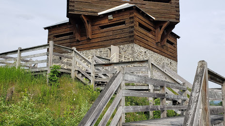
Photo
Where is located Petit-Sault Blockhouse
Petit-Sault Blockhouse — local attraction, which is located at 14 Avenue St Jean, Edmundston, NB E3V 1C8, Canada and belongs to the category — historical landmark. Average visitor rating for this place — 4.3 (according to 60 ratings, information from open sources and relevant for 2022).
Exact location — Petit-Sault Blockhouse, marked on the map with a red marker.
You can get directions to Petit-Sault Blockhouse on the map from your location.
What else is interesting in Edmundston? You can see all the sights if you go to the city page.
Coordinates
Petit-Sault Blockhouse, Canada coordinates in decimal format: latitude — 47.36378595585738, longitude — -68.32207700185296. When converted to degrees, minutes, seconds Petit-Sault Blockhouse has the following coordinates: 47°21′49.63 north latitude and -68°19′19.48 east longitude.
Nearby cities
The largest cities that are located nearby:
- Quebec — 229 km
- Levis — 232 km
- Saguenay — 233 km
- Trois-Rivières — 341 km
- Sherbrooke — 351 km
- Longueuil — 450 km
- Montreal — 456 km
- Laval — 460 km
- Dartmouth — 479 km
- Halifax — 480 km
- Manchester
 (United States) — 546 km
 - Lowell (United States) — 577 km
- Boston (United States) — 597 km
- Cambridge (United States) — 597 km
- Gatineau — 609 km
- Ottawa — 611 km
- Worcester (United States) — 632 km
- Amherst (United States) — 652 km
- Providence (United States) — 664 km
Distance to the capital
Distance to the capital (Washington) is about — 1175 km.