
 Pointe-à-la-Croix
Sainte-Irène, Quebec
Marsoui
Hecla
Muskrat Dam
Wunnummin Lake
Sainte-Brigitte-de-Laval
Drayton
Mauricie
Pointe-à-la-Croix
Sainte-Irène, Quebec
Marsoui
Hecla
Muskrat Dam
Wunnummin Lake
Sainte-Brigitte-de-Laval
Drayton
Mauricie
Les Jardins à Fleur de Peau on the map, Val-d'Or, Canada
Photo
Where is located Les Jardins à Fleur de Peau
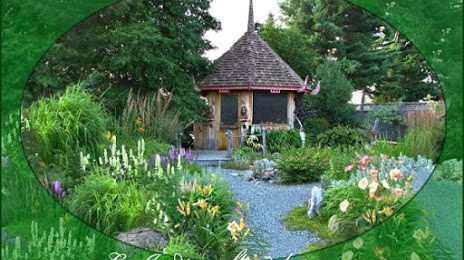
Les Jardins à Fleur de Peau — local attraction, which is located at 67 Chem. De La Baie-Jolie, Val-d'Or, QC J9P 7B5, Canada and belongs to the category — garden. Average visitor rating for this place — 4.6 (according to 14 ratings, information from open sources and relevant for 2022).
Exact location — Les Jardins à Fleur de Peau, marked on the map with a red marker.
You can get directions to Les Jardins à Fleur de Peau on the map from your location.
What else is interesting in Val-d'Or? You can see all the sights if you go to the city page.
Coordinates
Les Jardins à Fleur de Peau, Canada coordinates in decimal format: latitude — 48.142926917901, longitude — -77.77048520182588. When converted to degrees, minutes, seconds Les Jardins à Fleur de Peau has the following coordinates: 48°8′34.54 north latitude and -77°46′13.75 east longitude.
Nearby cities
The largest cities that are located nearby:
- Gatineau — 332 km
- Laval — 419 km
- Montreal — 436 km
- Longueuil — 436 km
- Barrie — 437 km
- Kingston — 440 km
- Trois-Rivières — 445 km
- Oshawa — 472 km
- Whitby — 473 km
- Richmond Hill — 484 km
- Markham — 485 km
- Vaughan — 491 km
- Saguenay — 495 km
- Toronto — 508 km
- Brampton — 508 km
- Quebec — 516 km
- Levis — 519 km
- Mississauga — 520 km
- Oakville — 534 km
Distance to the capital
Distance to the capital (Ottawa) is about — 341 km.