
 Pointe-à-la-Croix
Sainte-Irène, Quebec
Marsoui
Hecla
Muskrat Dam
Wunnummin Lake
Sainte-Brigitte-de-Laval
Drayton
Mauricie
Pointe-à-la-Croix
Sainte-Irène, Quebec
Marsoui
Hecla
Muskrat Dam
Wunnummin Lake
Sainte-Brigitte-de-Laval
Drayton
Mauricie
Haileybury Beach on the map, Temiskaming Shores, Canada
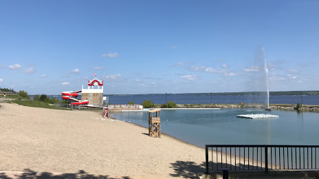
Photo
Where is located Haileybury Beach
Haileybury Beach — local attraction, which is located at 462 Farr Dr, Temiskaming Shores, ON, Canada and belongs to the category — public beach. Average visitor rating for this place — 4.7 (according to 89 ratings, information from open sources and relevant for 2022).
Exact location — Haileybury Beach, marked on the map with a red marker.
You can get directions to Haileybury Beach on the map from your location.
What else is interesting in Temiskaming Shores? You can see all the sights if you go to the city page.
Coordinates
Haileybury Beach, Canada coordinates in decimal format: latitude — 47.447708333999074, longitude — -79.63056500185006. When converted to degrees, minutes, seconds Haileybury Beach has the following coordinates: 47°26′51.75 north latitude and -79°37′50.03 east longitude.
Nearby cities
The largest cities that are located nearby:
- Barrie — 342 km
- Gatineau — 382 km
- Richmond Hill — 398 km
- Whitby — 401 km
- Markham — 402 km
- Oshawa — 402 km
- Vaughan — 403 km
- Brampton — 414 km
- Toronto — 424 km
- Mississauga — 430 km
- Guelph — 437 km
- Kingston — 441 km
- Oakville — 444 km
- Waterloo — 449 km
- Kitchener — 454 km
- Cambridge — 458 km
- Burlington — 459 km
- Hamilton — 468 km
- Saint Catharines — 479 km
Distance to the capital
Distance to the capital (Ottawa) is about — 376 km.