
 Gilserberg
Berlin
Bordesholm
Bechtolsheim
Aub
Triptis
Heppenheim
Biblis
Angermünde
Gilserberg
Berlin
Bordesholm
Bechtolsheim
Aub
Triptis
Heppenheim
Biblis
Angermünde
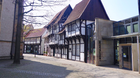
Altes Amtshaus Karl-Pollender-Stadtmuseum on the map, Bergkamen, Germany
Photo
Where is located Altes Amtshaus Karl-Pollender-Stadtmuseum
Altes Amtshaus Karl-Pollender-Stadtmuseum — local attraction, which is located at Kirchhof 13, 59368 Werne, Germany and belongs to the category — museum. Average visitor rating for this place — 4.3 (according to 37 ratings, information from open sources and relevant for 2022).
Exact location — Altes Amtshaus Karl-Pollender-Stadtmuseum, marked on the map with a red marker.
You can get directions to Altes Amtshaus Karl-Pollender-Stadtmuseum on the map from your location.
What else is interesting in Bergkamen? You can see all the sights if you go to the city page.
Coordinates
Altes Amtshaus Karl-Pollender-Stadtmuseum, Germany coordinates in decimal format: latitude — 51.66358916906586, longitude — 7.634319798300649. When converted to degrees, minutes, seconds Altes Amtshaus Karl-Pollender-Stadtmuseum has the following coordinates: 51°39′48.92 north latitude and 7°38′3.55 east longitude.
Nearby cities
The largest cities that are located nearby:
- Hamm — 13 km
- Dortmund — 17 km
- Witten — 28 km
- Hagen — 30 km
- Recklinghausen — 31 km
- Herne — 32 km
- Bochum — 33 km
- Münster — 38 km
- Gelsenkirchen — 40 km
- Essen — 47 km
- Bottrop — 49 km
- Wuppertal — 52 km
- Oberhausen — 55 km
- Mülheim — 57 km
- Remscheid — 58 km
- Solingen — 63 km
- Duisburg — 64 km
- Moers — 71 km
- Düsseldorf — 74 km
Distance to the capital
Distance to the capital (Berlin) is about — 406 km.