 Pointe-à-la-Croix
Sainte-Irène, Quebec
Marsoui
Hecla
Muskrat Dam
Wunnummin Lake
Sainte-Brigitte-de-Laval
Drayton
Mauricie
Pointe-à-la-Croix
Sainte-Irène, Quebec
Marsoui
Hecla
Muskrat Dam
Wunnummin Lake
Sainte-Brigitte-de-Laval
Drayton
Mauricie
Îles de la Paix National Wildlife Area on the map, Pointe-Claire, Canada
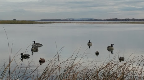
Photo
Where is located Îles de la Paix National Wildlife Area
Îles de la Paix National Wildlife Area — local attraction, which is located at Maple Grove, Léry, QC, Canada and belongs to the category — wildlife refuge. Average visitor rating for this place — 4.6 (according to 83 ratings, information from open sources and relevant for 2022).
Exact location — Îles de la Paix National Wildlife Area, marked on the map with a red marker.
You can get directions to Îles de la Paix National Wildlife Area on the map from your location.
What else is interesting in Pointe-Claire? You can see all the sights if you go to the city page.
Coordinates
Îles de la Paix National Wildlife Area, Canada coordinates in decimal format: latitude — 45.334601516364685, longitude — -73.84514090192198. When converted to degrees, minutes, seconds Îles de la Paix National Wildlife Area has the following coordinates: 45°20′4.57 north latitude and -73°50′42.51 east longitude.
Nearby cities
The largest cities that are located nearby:
- Laval — 16 km
- Montreal — 18 km
- Longueuil — 23 km
- Trois-Rivières — 136 km
- Gatineau — 147 km
- Sherbrooke — 149 km
- Levis — 239 km
- Quebec — 243 km
- Kingston — 253 km
- Syracuse
 (United States) — 328 km
 - Manchester (United States) — 333 km
- Amherst (United States) — 362 km
- Lowell (United States) — 373 km
- Saguenay — 383 km
- Springfield (United States) — 386 km
- Worcester (United States) — 391 km
- Rochester (United States) — 400 km
- Cambridge (United States) — 407 km
- Boston (United States) — 410 km
Distance to the capital
Distance to the capital (Ottawa) is about — 145 km.