
 Gilserberg
Berlin
Bordesholm
Bechtolsheim
Aub
Triptis
Heppenheim
Biblis
Angermünde
Gilserberg
Berlin
Bordesholm
Bechtolsheim
Aub
Triptis
Heppenheim
Biblis
Angermünde
Ruin Zähringer Burg on the map, Freiburg, Germany
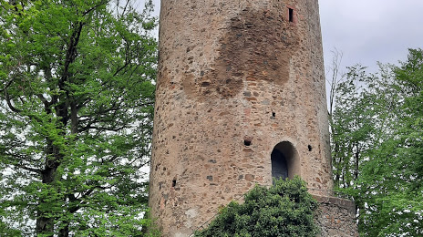
Photo
Where is located Ruin Zähringer Burg
Ruin Zähringer Burg — local attraction, which is located at Schloßhaldenweg, 79194 Gundelfingen, Germany and belongs to the category — historical landmark. Average visitor rating for this place — 4.3 (according to 178 ratings, information from open sources and relevant for 2022).
Exact location — Ruin Zähringer Burg, marked on the map with a red marker.
You can get directions to Ruin Zähringer Burg on the map from your location.
What else is interesting in Freiburg? You can see all the sights if you go to the city page.
Coordinates
Ruin Zähringer Burg, Germany coordinates in decimal format: latitude — 48.02551690235124, longitude — 7.8839268981699995. When converted to degrees, minutes, seconds Ruin Zähringer Burg has the following coordinates: 48°1′31.86 north latitude and 7°53′2.14 east longitude.
Nearby cities
The largest cities that are located nearby:
- Mulhouse
 (France) — 47 km
 - Basel
 (Switzerland) — 51 km
 - Strasbourg (France) — 64 km
- Zurich (Switzerland) — 87 km
- Reutlingen — 114 km
- Pforzheim — 117 km
- Karlsruhe — 119 km
- Bern (Switzerland) — 120 km
- Stuttgart — 130 km
- Nancy (France) — 143 km
- Saarbrücken — 150 km
- Besançon (France) — 160 km
- Heilbronn — 161 km
- Ulm — 164 km
- Heidelberg — 166 km
- Ludwigshafen — 169 km
- Mannheim — 171 km
- Metz (France) — 173 km
- Lausanne (Switzerland) — 188 km
Distance to the capital
Distance to the capital (Berlin) is about — 635 km.