 Pointe-à-la-Croix
Sainte-Irène, Quebec
Marsoui
Hecla
Muskrat Dam
Wunnummin Lake
Sainte-Brigitte-de-Laval
Drayton
Mauricie
Pointe-à-la-Croix
Sainte-Irène, Quebec
Marsoui
Hecla
Muskrat Dam
Wunnummin Lake
Sainte-Brigitte-de-Laval
Drayton
Mauricie
Coteau Saint-Paul on the map, Granby, Canada
Photo
Where is located Coteau Saint-Paul
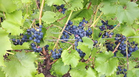
Coteau Saint-Paul — local attraction, which is located at 1595 Rue Principale E, Saint-Paul-d'Abbotsford, QC J0E 1A0, Canada and belongs to the category — winery. Average visitor rating for this place — 4.6 (according to 48 ratings, information from open sources and relevant for 2022).
Exact location — Coteau Saint-Paul, marked on the map with a red marker.
You can get directions to Coteau Saint-Paul on the map from your location.
What else is interesting in Granby? You can see all the sights if you go to the city page.
Coordinates
Coteau Saint-Paul, Canada coordinates in decimal format: latitude — 45.433598006270735, longitude — -72.85770640191865. When converted to degrees, minutes, seconds Coteau Saint-Paul has the following coordinates: 45°26′0.95 north latitude and -72°51′27.74 east longitude.
Nearby cities
The largest cities that are located nearby:
- Longueuil — 62 km
- Montreal — 65 km
- Sherbrooke — 66 km
- Laval — 79 km
- Trois-Rivières — 105 km
- Levis — 186 km
- Quebec — 192 km
- Gatineau — 230 km
- Manchester
 (United States) — 286 km
 - Kingston — 324 km
- Lowell (United States) — 327 km
- Amherst (United States) — 339 km
- Worcester (United States) — 355 km
- Saguenay — 356 km
- Cambridge (United States) — 360 km
- Boston (United States) — 363 km
- Springfield (United States) — 365 km
- Syracuse (United States) — 379 km
- Hartford (United States) — 402 km
Distance to the capital
Distance to the capital (Ottawa) is about — 222 km.