 Pointe-à-la-Croix
Sainte-Irène, Quebec
Marsoui
Hecla
Muskrat Dam
Wunnummin Lake
Sainte-Brigitte-de-Laval
Drayton
Mauricie
Pointe-à-la-Croix
Sainte-Irène, Quebec
Marsoui
Hecla
Muskrat Dam
Wunnummin Lake
Sainte-Brigitte-de-Laval
Drayton
Mauricie
Golf Club Saint-Jérôme on the map, Saint-Jérôme, Canada
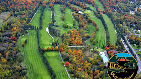
Photo
Where is located Golf Club Saint-Jérôme
Golf Club Saint-Jérôme — local attraction, which is located at 2019 Mnt Sainte-Thérèse, Saint-Jérôme, QC J5L 0L8, Canada and belongs to the category — golf club. Average visitor rating for this place — 4.4 (according to 116 ratings, information from open sources and relevant for 2022).
Exact location — Golf Club Saint-Jérôme, marked on the map with a red marker.
You can get directions to Golf Club Saint-Jérôme on the map from your location.
What else is interesting in Saint-Jérôme? You can see all the sights if you go to the city page.
Coordinates
Golf Club Saint-Jérôme, Canada coordinates in decimal format: latitude — 45.83131205517051, longitude — -74.06167860190534. When converted to degrees, minutes, seconds Golf Club Saint-Jérôme has the following coordinates: 45°49′52.72 north latitude and -74°3′42.04 east longitude.
Nearby cities
The largest cities that are located nearby:
- Laval — 29 km
- Montreal — 45 km
- Longueuil — 46 km
- Trois-Rivières — 128 km
- Gatineau — 136 km
- Sherbrooke — 170 km
- Levis — 235 km
- Quebec — 238 km
- Kingston — 260 km
- Syracuse
 (United States) — 348 km
 - Saguenay — 364 km
- Manchester (United States) — 370 km
- Amherst (United States) — 399 km
- Rochester (United States) — 410 km
- Lowell (United States) — 410 km
- Springfield (United States) — 422 km
- Worcester (United States) — 428 km
- Oshawa — 439 km
- Cambridge (United States) — 444 km
Distance to the capital
Distance to the capital (Ottawa) is about — 135 km.