
 Gilserberg
Berlin
Bordesholm
Bechtolsheim
Aub
Triptis
Heppenheim
Biblis
Angermünde
Gilserberg
Berlin
Bordesholm
Bechtolsheim
Aub
Triptis
Heppenheim
Biblis
Angermünde
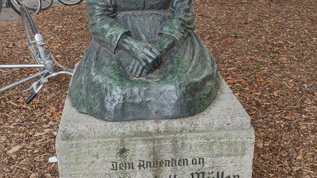
Charlotte-Müller-Denkmal on the map, Göttingen, Germany
Photo
Where is located Charlotte-Müller-Denkmal
Charlotte-Müller-Denkmal — local attraction, which is located at Berliner Str. 11, 37073 Göttingen, Germany and belongs to the category — historical landmark. Average visitor rating for this place — 5.0 (according to 5 ratings, information from open sources and relevant for 2022).
Exact location — Charlotte-Müller-Denkmal, marked on the map with a red marker.
You can get directions to Charlotte-Müller-Denkmal on the map from your location.
What else is interesting in Göttingen? You can see all the sights if you go to the city page.
Coordinates
Charlotte-Müller-Denkmal, Germany coordinates in decimal format: latitude — 51.53609371181892, longitude — 9.927386298137545. When converted to degrees, minutes, seconds Charlotte-Müller-Denkmal has the following coordinates: 51°32′9.94 north latitude and 9°55′38.59 east longitude.
Nearby cities
The largest cities that are located nearby:
- Kassel — 39 km
- Hildesheim — 68 km
- Salzgitter — 73 km
- Paderborn — 82 km
- Brunswick — 90 km
- Hanover — 93 km
- Erfurt — 99 km
- Bielefeld — 109 km
- Wolfsburg — 114 km
- Magdeburg — 133 km
- Hamm — 145 km
- Osnabrück — 150 km
- Siegen — 151 km
- Münster — 163 km
- Gera — 168 km
- Dortmund — 169 km
- Hagen — 170 km
- Leipzig — 171 km
- Witten — 177 km
Distance to the capital
Distance to the capital (Berlin) is about — 262 km.