 Pointe-à-la-Croix
Sainte-Irène, Quebec
Marsoui
Hecla
Muskrat Dam
Wunnummin Lake
Sainte-Brigitte-de-Laval
Drayton
Mauricie
Pointe-à-la-Croix
Sainte-Irène, Quebec
Marsoui
Hecla
Muskrat Dam
Wunnummin Lake
Sainte-Brigitte-de-Laval
Drayton
Mauricie
Plage Furguson Sep Iles on the map, Sept-Iles, Canada
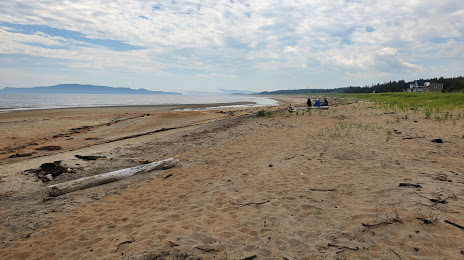
Photo
Where is located Plage Furguson Sep Iles
Plage Furguson Sep Iles — local attraction, which is located at Quebec and belongs to the category — -. Average visitor rating for this place — 4.6 (according to 33 ratings, information from open sources and relevant for 2022).
Exact location — Plage Furguson Sep Iles, marked on the map with a red marker.
You can get directions to Plage Furguson Sep Iles on the map from your location.
What else is interesting in Sept-Iles? You can see all the sights if you go to the city page.
Coordinates
Plage Furguson Sep Iles, Canada coordinates in decimal format: latitude — 50.203352303020814, longitude — -66.31558564623488. When converted to degrees, minutes, seconds Plage Furguson Sep Iles has the following coordinates: 50°12′12.07 north latitude and -66°18′56.11 east longitude.
Nearby cities
The largest cities that are located nearby:
- Saguenay — 397 km
- Quebec — 527 km
- Levis — 533 km
- Trois-Rivières — 636 km
- Dartmouth — 652 km
- Halifax — 653 km
- Sherbrooke — 683 km
- Longueuil — 757 km
- Laval — 763 km
- Montreal — 763 km
- Gatineau — 893 km
- Manchester
 (United States) — 897 km
 - Lowell (United States) — 929 km
- Boston (United States) — 949 km
- Cambridge (United States) — 949 km
- Worcester (United States) — 985 km
- Amherst (United States) — 1004 km
- Providence (United States) — 1016 km
- Springfield (United States) — 1032 km
Distance to the capital
Distance to the capital (Ottawa) is about — 879 km.