
 Puerto de la Duquesa
La Serna de Iguña
Pumalverde
Puentenansa
La Iglesia
Casar de Periedo
Fuengirola
Renedo de Piélagos
Villabanez
Puerto de la Duquesa
La Serna de Iguña
Pumalverde
Puentenansa
La Iglesia
Casar de Periedo
Fuengirola
Renedo de Piélagos
Villabanez
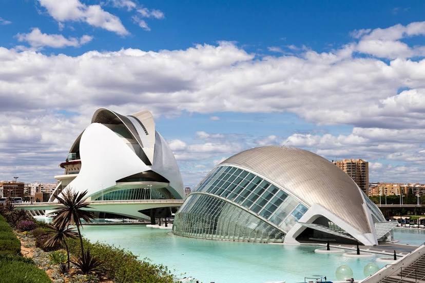
Ciudad de las Artes y las Ciencias on the map, Valencia, Spain
Photo
Where is located Ciudad de las Artes y las Ciencias
Ciudad de las Artes y las Ciencias — local attraction, which is located at Av. del Professor López Piñero, 7, 46013 València, Valencia, Spain and belongs to the category — building complex. Average visitor rating for this place — 4.6 (according to 89741 rating, information from open sources and relevant for 2022).
Exact location — Ciudad de las Artes y las Ciencias, marked on the map with a red marker.
You can get directions to Ciudad de las Artes y las Ciencias on the map from your location.
What else is interesting in Valencia? You can see all the sights if you go to the city page.
Coordinates
Ciudad de las Artes y las Ciencias, Spain coordinates in decimal format: latitude — 39.454651410976425, longitude — -0.3508873691084436. When converted to degrees, minutes, seconds Ciudad de las Artes y las Ciencias has the following coordinates: 39°27′16.75 north latitude and -0°21′3.19 east longitude.
Nearby cities
The largest cities that are located nearby:
- Albacete — 138 km
- Murcia — 176 km
- Cartagena — 211 km
- Tarragona — 227 km
- Zaragoza — 245 km
- Lleida — 251 km
- Palma — 258 km
- Alcala de Henares — 275 km
- Torrejón de Ardoz — 283 km
- L'Hospitalet de Llobregat — 295 km
- Getafe — 298 km
- Alcobendas — 298 km
- Leganés — 301 km
- Fuenlabrada — 303 km
- Terrassa — 304 km
- Santa Coloma de Gramenet — 306 km
- Alcorcón — 307 km
- Badalona — 308 km
- Sabadell — 308 km
Distance to the capital
Distance to the capital (Madrid) is about — 305 km.