
 Puerto de la Duquesa
La Serna de Iguña
Pumalverde
Puentenansa
La Iglesia
Casar de Periedo
Fuengirola
Renedo de Piélagos
Villabanez
Puerto de la Duquesa
La Serna de Iguña
Pumalverde
Puentenansa
La Iglesia
Casar de Periedo
Fuengirola
Renedo de Piélagos
Villabanez
Castelo do Castro on the map, Vigo, Spain
Photo
Where is located Castelo do Castro
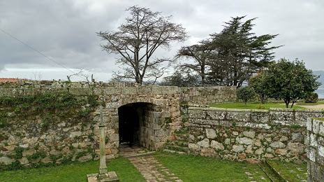
Castelo do Castro — local attraction, which is located at P.º Rosalía de Castro, 5, 36203 Vigo, Pontevedra, Spain and belongs to the category — castle. Average visitor rating for this place — 4.6 (according to 4654 ratings, information from open sources and relevant for 2022).
Exact location — Castelo do Castro, marked on the map with a red marker.
You can get directions to Castelo do Castro on the map from your location.
What else is interesting in Vigo? You can see all the sights if you go to the city page.
Coordinates
Castelo do Castro, Spain coordinates in decimal format: latitude — 42.232595572132254, longitude — -8.726445592313539. When converted to degrees, minutes, seconds Castelo do Castro has the following coordinates: 42°13′57.34 north latitude and -8°43′35.2 east longitude.
Nearby cities
The largest cities that are located nearby:
- Ourense — 71 km
- Braga
 (Portugal) — 81 km
 - Porto (Portugal) — 120 km
- A Coruña — 126 km
- Coimbra (Portugal) — 227 km
- León — 260 km
- Oviedo — 262 km
- Gijón — 284 km
- Salamanca — 291 km
- Valladolid — 336 km
- Amadora (Portugal) — 388 km
- Queluz (Portugal) — 388 km
- Lisbon (Portugal) — 391 km
- Badajoz — 401 km
- Burgos — 411 km
- Santander — 417 km
- Móstoles — 461 km
- Alcorcón — 462 km
- Alcobendas — 467 km
Distance to the capital
Distance to the capital (Madrid) is about — 466 km.