
 Litoral Del Bajo San Juan
El Cantón de San Pablo
Juan Frío
Santa Barbara
El Juncal
Dibulla
Vereda Campo Alegre
San Pablo
Guaramito
Litoral Del Bajo San Juan
El Cantón de San Pablo
Juan Frío
Santa Barbara
El Juncal
Dibulla
Vereda Campo Alegre
San Pablo
Guaramito
Parroquia de San Nicolás de Tolentino on the map, Barranquilla, Colombia
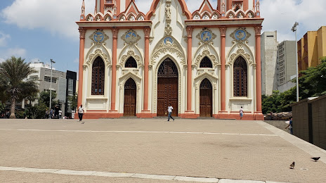
Photo
Where is located Parroquia de San Nicolás de Tolentino
Parroquia de San Nicolás de Tolentino — local attraction, which is located at Av. el Progreso #35, Barranquilla, Atlántico, Colombia and belongs to the category — parish. Average visitor rating for this place — 4.5 (according to 1273 ratings, information from open sources and relevant for 2022).
Exact location — Parroquia de San Nicolás de Tolentino, marked on the map with a red marker.
You can get directions to Parroquia de San Nicolás de Tolentino on the map from your location.
What else is interesting in Barranquilla? You can see all the sights if you go to the city page.
Coordinates
Parroquia de San Nicolás de Tolentino, Colombia coordinates in decimal format: latitude — 10.980062365192161, longitude — -74.77803869296329. When converted to degrees, minutes, seconds Parroquia de San Nicolás de Tolentino has the following coordinates: 10°58′48.22 north latitude and -74°46′40.94 east longitude.
Nearby cities
The largest cities that are located nearby:
- Soledad — 7 km
- Malambo — 12 km
- Santa Marta — 70 km
- Cartagena — 101 km
- Valledupar — 176 km
- Magangué — 191 km
- Sincelejo — 196 km
- Monteria — 273 km
- Maicao — 280 km
- Maracaibo
 (Venezuela) — 345 km
 - Cabimas (Venezuela) — 367 km
- Cúcuta — 423 km
- Barrancabermeja — 444 km
- San Cristobal (Venezuela) — 452 km
- Bucaramanga — 462 km
- Giron — 466 km
- Floridablanca — 471 km
- Ejido (Venezuela) — 471 km
- Merida (Venezuela) — 477 km
Distance to the capital
Distance to the capital (Bogota) is about — 714 km.