
 Puerto de la Duquesa
La Serna de Iguña
Pumalverde
Puentenansa
La Iglesia
Casar de Periedo
Fuengirola
Renedo de Piélagos
Villabanez
Puerto de la Duquesa
La Serna de Iguña
Pumalverde
Puentenansa
La Iglesia
Casar de Periedo
Fuengirola
Renedo de Piélagos
Villabanez
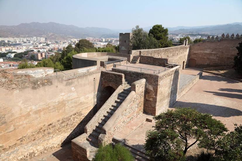
Castillo de Gibralfaro on the map, Málaga, Spain
Photo
Where is located Castillo de Gibralfaro
Castillo de Gibralfaro — local attraction, which is located at Cam. Gibralfaro, 11, 29016 Málaga, Spain and belongs to the category — castle. Average visitor rating for this place — 4.5 (according to 10050 ratings, information from open sources and relevant for 2022).
Exact location — Castillo de Gibralfaro, marked on the map with a red marker.
You can get directions to Castillo de Gibralfaro on the map from your location.
What else is interesting in Málaga? You can see all the sights if you go to the city page.
Coordinates
Castillo de Gibralfaro, Spain coordinates in decimal format: latitude — 36.72377007753297, longitude — -4.411222739268167. When converted to degrees, minutes, seconds Castillo de Gibralfaro has the following coordinates: 36°43′25.57 north latitude and -4°24′40.4 east longitude.
Nearby cities
The largest cities that are located nearby:
- Marbella — 47 km
- Granada — 88 km
- Algeciras — 113 km
- Jaén — 130 km
- Córdoba — 133 km
- Dos Hermanas — 146 km
- Jerez — 151 km
- Tetouan
 (Morocco) — 153 km
 - Tangier (Morocco) — 165 km
- Cádiz — 167 km
- Almería — 174 km
- Nador (Morocco) — 218 km
- Huelva — 230 km
- Taounate (Morocco) — 242 km
- Taza (Morocco) — 279 km
- Cartagena — 316 km
- Murcia — 319 km
- Oujda (Morocco) — 320 km
- Badajoz — 324 km
Distance to the capital
Distance to the capital (Madrid) is about — 415 km.