
 Józefów nad Wisłą
Gorzyce Wielkie
Rogówek
Sromowce Niżne
Wyszków County
Kruszewo
Jantar
Sady Górne
Nagoszewo
Józefów nad Wisłą
Gorzyce Wielkie
Rogówek
Sromowce Niżne
Wyszków County
Kruszewo
Jantar
Sady Górne
Nagoszewo
Pałac Sokoła on the map, Pruszków, Poland
Photo
Where is located Pałac Sokoła
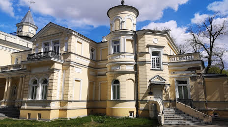
Pałac Sokoła — local attraction, which is located at Tadeusza Kościuszki 41, 00-001 Pruszków, Poland and belongs to the category — historical landmark. Average visitor rating for this place — 4.7 (according to 6 ratings, information from open sources and relevant for 2022).
Exact location — Pałac Sokoła, marked on the map with a red marker.
You can get directions to Pałac Sokoła on the map from your location.
What else is interesting in Pruszków? You can see all the sights if you go to the city page.
Coordinates
Pałac Sokoła, Poland coordinates in decimal format: latitude — 52.165888613996884, longitude — 20.801588308028553. When converted to degrees, minutes, seconds Pałac Sokoła has the following coordinates: 52°9′57.2 north latitude and 20°48′5.72 east longitude.
Nearby cities
The largest cities that are located nearby:
- Plock — 85 km
- Radom — 88 km
- Łódź — 103 km
- Wloclawek — 128 km
- Kielce — 145 km
- Lublin — 159 km
- Torun — 174 km
- Olsztyn — 179 km
- Bialystok — 189 km
- Częstochowa — 191 km
- Kalisz — 192 km
- Brest
 (Belarus) — 199 km
 - Bydgoszcz — 214 km
- Dabrowa Gornicza — 234 km
- Elblag — 238 km
- Tarnow — 239 km
- Sosnowiec — 241 km
- Kraków — 241 km
- Bytom — 242 km
Distance to the capital
Distance to the capital (Warsaw) is about — 16 km.