
 Puerto de la Duquesa
La Serna de Iguña
Pumalverde
Puentenansa
La Iglesia
Casar de Periedo
Fuengirola
Renedo de Piélagos
Villabanez
Puerto de la Duquesa
La Serna de Iguña
Pumalverde
Puentenansa
La Iglesia
Casar de Periedo
Fuengirola
Renedo de Piélagos
Villabanez
Playa Mera on the map, A Coruña, Spain
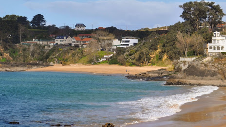
Photo
Where is located Playa Mera
Playa Mera — local attraction, which is located at no data and belongs to the category — -. Average visitor rating for this place — 4.6 (according to 2716 ratings, information from open sources and relevant for 2022).
Exact location — Playa Mera, marked on the map with a red marker.
You can get directions to Playa Mera on the map from your location.
What else is interesting in A Coruña? You can see all the sights if you go to the city page.
Coordinates
Playa Mera, Spain coordinates in decimal format: latitude — 43.379998646398775, longitude — -8.341703738462831. When converted to degrees, minutes, seconds Playa Mera has the following coordinates: 43°22′48 north latitude and -8°20′30.13 east longitude.
Nearby cities
The largest cities that are located nearby:
- Ourense — 122 km
- Vigo — 127 km
- Braga
 (Portugal) — 201 km
 - Oviedo — 206 km
- Gijón — 221 km
- Porto (Portugal) — 244 km
- León — 246 km
- Coimbra (Portugal) — 349 km
- Salamanca — 350 km
- Valladolid — 359 km
- Santander — 369 km
- Burgos — 401 km
- Bilbao — 441 km
- Vitoria-Gasteiz — 468 km
- Logroño — 497 km
- Alcobendas — 508 km
- Móstoles — 510 km
- Alcorcón — 510 km
- Badajoz — 511 km
Distance to the capital
Distance to the capital (Madrid) is about — 506 km.