
 Gilserberg
Berlin
Bordesholm
Bechtolsheim
Aub
Triptis
Heppenheim
Biblis
Angermünde
Gilserberg
Berlin
Bordesholm
Bechtolsheim
Aub
Triptis
Heppenheim
Biblis
Angermünde
Museumsanlage Osterholz-Scharmbeck on the map, Bremen, Germany
Photo
Where is located Museumsanlage Osterholz-Scharmbeck
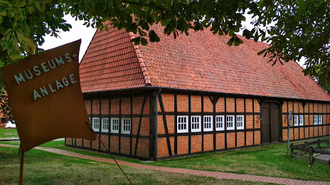
Museumsanlage Osterholz-Scharmbeck — local attraction, which is located at Bördestraße 42, 27711 Osterholz-Scharmbeck, Germany and belongs to the category — museum. Average visitor rating for this place — 4.4 (according to 39 ratings, information from open sources and relevant for 2022).
Exact location — Museumsanlage Osterholz-Scharmbeck, marked on the map with a red marker.
You can get directions to Museumsanlage Osterholz-Scharmbeck on the map from your location.
What else is interesting in Bremen? You can see all the sights if you go to the city page.
Coordinates
Museumsanlage Osterholz-Scharmbeck, Germany coordinates in decimal format: latitude — 53.223616416987255, longitude — 8.80890410806804. When converted to degrees, minutes, seconds Museumsanlage Osterholz-Scharmbeck has the following coordinates: 53°13′25.02 north latitude and 8°48′32.05 east longitude.
Nearby cities
The largest cities that are located nearby:
- Bremerhaven — 53 km
- Hanover — 100 km
- Osnabrück — 102 km
- Bielefeld — 117 km
- Hildesheim — 129 km
- Emmen
 (Netherlands) — 131 km
 - Salzgitter — 146 km
- Brunswick — 147 km
- Münster — 147 km
- Groningen (Netherlands) — 149 km
- Paderborn — 150 km
- Wolfsburg — 152 km
- Enschede (Netherlands) — 160 km
- Kiel — 162 km
- Hamm — 169 km
- Göttingen — 187 km
- Zwolle (Netherlands) — 193 km
- Recklinghausen — 196 km
- Dortmund — 196 km
Distance to the capital
Distance to the capital (Berlin) is about — 318 km.