
 Puerto de la Duquesa
La Serna de Iguña
Pumalverde
Puentenansa
La Iglesia
Casar de Periedo
Fuengirola
Renedo de Piélagos
Villabanez
Puerto de la Duquesa
La Serna de Iguña
Pumalverde
Puentenansa
La Iglesia
Casar de Periedo
Fuengirola
Renedo de Piélagos
Villabanez
Castle Of San Cristobal on the map, Las Palmas de Gran Canaria, Spain
Photo
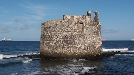
Where is located Castle Of San Cristobal
Castle Of San Cristobal — local attraction, which is located at Castillo de San Cristóbal, Las Palmas de Gran Canaria, Las Palmas, Spain and belongs to the category — historical landmark. Average visitor rating for this place — 4.5 (according to 433 ratings, information from open sources and relevant for 2022).
Exact location — Castle Of San Cristobal, marked on the map with a red marker.
You can get directions to Castle Of San Cristobal on the map from your location.
What else is interesting in Las Palmas de Gran Canaria? You can see all the sights if you go to the city page.
Coordinates
Castle Of San Cristobal, Spain coordinates in decimal format: latitude — 28.08234112239887, longitude — -15.41543309269551. When converted to degrees, minutes, seconds Castle Of San Cristobal has the following coordinates: 28°4′56.43 north latitude and -15°24′55.56 east longitude.
Nearby cities
The largest cities that are located nearby:
- Telde — 14 km
- Santa Cruz de Tenerife — 88 km
- Agadir
 (Morocco) — 612 km
 - Essaouira (Morocco) — 653 km
- Safi (Morocco) — 742 km
- Marrakesh (Morocco) — 799 km
- El Jadida (Morocco) — 855 km
- Ouarzazate (Morocco) — 864 km
- Azilal (Morocco) — 934 km
- Casablanca (Morocco) — 941 km
- Khouribga (Morocco) — 950 km
- Mohammedia (Morocco) — 963 km
- Temara (Morocco) — 1012 km
- Sale (Morocco) — 1028 km
- Khenifra (Morocco) — 1051 km
- Kenitra (Morocco) — 1055 km
- Khemisset (Morocco) — 1066 km
- Meknes (Morocco) — 1109 km
- Nouakchott
 (Mauritania) — 1110 km
Distance to the capital
Distance to the capital (Madrid) is about — 1741 km.