
 Litoral Del Bajo San Juan
El Cantón de San Pablo
Juan Frío
Santa Barbara
El Juncal
Dibulla
Vereda Campo Alegre
San Pablo
Guaramito
Litoral Del Bajo San Juan
El Cantón de San Pablo
Juan Frío
Santa Barbara
El Juncal
Dibulla
Vereda Campo Alegre
San Pablo
Guaramito
Plazoleta Jairo Varela on the map, Cali, Colombia
Photo
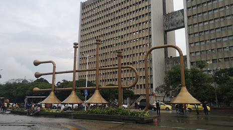
Where is located Plazoleta Jairo Varela
Plazoleta Jairo Varela — local attraction, which is located at Av. 2 Nte. #10 Norte-1 a 10 Norte-75,, Cali, Valle del Cauca, Colombia and belongs to the category — park. Average visitor rating for this place — 4.6 (according to 8722 ratings, information from open sources and relevant for 2022).
Exact location — Plazoleta Jairo Varela, marked on the map with a red marker.
You can get directions to Plazoleta Jairo Varela on the map from your location.
What else is interesting in Cali? You can see all the sights if you go to the city page.
Coordinates
Plazoleta Jairo Varela, Colombia coordinates in decimal format: latitude — 3.454916432132983, longitude — -76.53481289300771. When converted to degrees, minutes, seconds Plazoleta Jairo Varela has the following coordinates: 3°27′17.7 north latitude and -76°32′5.33 east longitude.
Nearby cities
The largest cities that are located nearby:
- Palmira — 26 km
- Buga — 56 km
- Buenaventura — 78 km
- Tuluá — 80 km
- Popayán — 110 km
- Neiva — 147 km
- Armenia — 153 km
- Cartago — 159 km
- Pereira — 177 km
- Ibagué — 180 km
- Dos Quebradas — 181 km
- Manizales — 211 km
- Girardot — 211 km
- Florencia — 225 km
- Pasto — 259 km
- Soacha — 283 km
- Itagüi — 318 km
- Envigado — 319 km
- Villavicencio — 328 km
Distance to the capital
Distance to the capital (Bogota) is about — 301 km.