 Bel-Ha
San Jose El Alto
El Porvenir
Nueva Palestina
Santa Lucía
Chemax
La Morita
Temoac
Zacualpan
Bel-Ha
San Jose El Alto
El Porvenir
Nueva Palestina
Santa Lucía
Chemax
La Morita
Temoac
Zacualpan
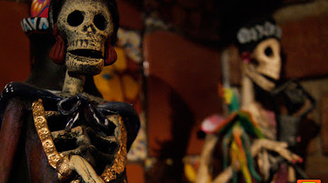
Museo de la Katrina on the map, Saltillo, Mexico
Photo
Where is located Museo de la Katrina
Museo de la Katrina — local attraction, which is located at Calle Ignacio Allende 720 A, Centro, 25000 Saltillo, Coah., Mexico and belongs to the category — history museum. Average visitor rating for this place — 4.5 (according to 813 ratings, information from open sources and relevant for 2022).
Exact location — Museo de la Katrina, marked on the map with a red marker.
You can get directions to Museo de la Katrina on the map from your location.
What else is interesting in Saltillo? You can see all the sights if you go to the city page.
Coordinates
Museo de la Katrina, Mexico coordinates in decimal format: latitude — 25.416400150884687, longitude — -101.00333429275184. When converted to degrees, minutes, seconds Museo de la Katrina has the following coordinates: 25°24′59.04 north latitude and -101°0′12 east longitude.
Nearby cities
The largest cities that are located nearby:
- Santa Catarina — 60 km
- San Pedro Garza García — 64 km
- Monterrey — 73 km
- General Escobedo — 78 km
- Guadalupe — 78 km
- San Nicolas de los Garza — 79 km
- Apodaca — 89 km
- Monclova — 169 km
- Matamoros — 223 km
- Torreón — 241 km
- Gómez Palacio — 249 km
- Ciudad Victoria — 265 km
- Nuevo Laredo — 267 km
- Laredo
 (United States) — 276 km
 - Reynosa — 280 km
- McAllen (United States) — 287 km
- Fresnillo — 313 km
- Zacatecas — 335 km
- Brownsville (United States) — 352 km
Distance to the capital
Distance to the capital (Mexico City) is about — 693 km.