
 Gilserberg
Berlin
Bordesholm
Bechtolsheim
Aub
Triptis
Heppenheim
Biblis
Angermünde
Gilserberg
Berlin
Bordesholm
Bechtolsheim
Aub
Triptis
Heppenheim
Biblis
Angermünde
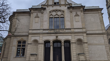
Osthaus-Museum Hagen on the map, Hagen, Germany
Photo
Where is located Osthaus-Museum Hagen
Osthaus-Museum Hagen — local attraction, which is located at Museumspl. 1, 58095 Hagen, Germany and belongs to the category — art museum. Average visitor rating for this place — 4.4 (according to 233 ratings, information from open sources and relevant for 2022).
Exact location — Osthaus-Museum Hagen, marked on the map with a red marker.
You can get directions to Osthaus-Museum Hagen on the map from your location.
What else is interesting in Hagen? You can see all the sights if you go to the city page.
Coordinates
Osthaus-Museum Hagen, Germany coordinates in decimal format: latitude — 51.35600758007005, longitude — 7.47283640799856. When converted to degrees, minutes, seconds Osthaus-Museum Hagen has the following coordinates: 51°21′21.63 north latitude and 7°28′22.21 east longitude.
Nearby cities
The largest cities that are located nearby:
- Witten — 11 km
- Dortmund — 16 km
- Bochum — 21 km
- Wuppertal — 25 km
- Herne — 26 km
- Remscheid — 28 km
- Gelsenkirchen — 31 km
- Essen — 33 km
- Recklinghausen — 33 km
- Solingen — 34 km
- Bottrop — 40 km
- Mülheim — 40 km
- Hamm — 42 km
- Oberhausen — 44 km
- Bergisch Gladbach — 48 km
- Duisburg — 49 km
- Düsseldorf — 50 km
- Neuss — 57 km
- Moers — 57 km
Distance to the capital
Distance to the capital (Berlin) is about — 427 km.