 Pointe-à-la-Croix
Sainte-Irène, Quebec
Marsoui
Hecla
Muskrat Dam
Wunnummin Lake
Sainte-Brigitte-de-Laval
Drayton
Mauricie
Pointe-à-la-Croix
Sainte-Irène, Quebec
Marsoui
Hecla
Muskrat Dam
Wunnummin Lake
Sainte-Brigitte-de-Laval
Drayton
Mauricie
Îles de la Paix National Wildlife Area on the map, Beauharnois, Canada
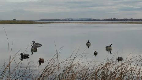
Photo
Where is located Îles de la Paix National Wildlife Area
Îles de la Paix National Wildlife Area — local attraction, which is located at Maple Grove, Léry, QC, Canada and belongs to the category — wildlife refuge. Average visitor rating for this place — 4.6 (according to 84 ratings, information from open sources and relevant for 2022).
Exact location — Îles de la Paix National Wildlife Area, marked on the map with a red marker.
You can get directions to Îles de la Paix National Wildlife Area on the map from your location.
What else is interesting in Beauharnois? You can see all the sights if you go to the city page.
Coordinates
Îles de la Paix National Wildlife Area, Canada coordinates in decimal format: latitude — 45.33437148491341, longitude — -73.84532329221273. When converted to degrees, minutes, seconds Îles de la Paix National Wildlife Area has the following coordinates: 45°20′3.74 north latitude and -73°50′43.16 east longitude.
Nearby cities
The largest cities that are located nearby:
- Montreal — 32 km
- Laval — 35 km
- Longueuil — 38 km
- Gatineau — 142 km
- Trois-Rivières — 153 km
- Sherbrooke — 155 km
- Kingston — 239 km
- Levis — 254 km
- Quebec — 259 km
- Syracuse
 (United States) — 311 km
 - Manchester (United States) — 323 km
- Amherst (United States) — 348 km
- Lowell (United States) — 362 km
- Springfield (United States) — 371 km
- Worcester (United States) — 378 km
- Rochester (United States) — 384 km
- Cambridge (United States) — 396 km
- Boston (United States) — 400 km
- Saguenay — 401 km
Distance to the capital
Distance to the capital (Ottawa) is about — 145 km.