
 Gilserberg
Berlin
Bordesholm
Bechtolsheim
Aub
Triptis
Heppenheim
Biblis
Angermünde
Gilserberg
Berlin
Bordesholm
Bechtolsheim
Aub
Triptis
Heppenheim
Biblis
Angermünde
Heimat & Handwerks-Museum Stolberg on the map, Aachen, Germany
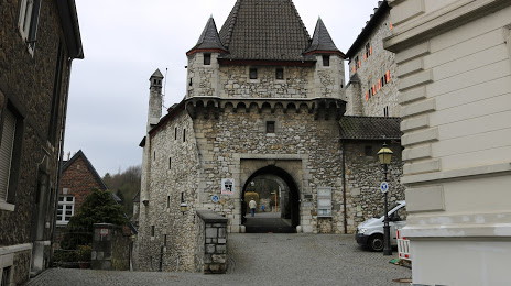
Photo
Where is located Heimat & Handwerks-Museum Stolberg
Heimat & Handwerks-Museum Stolberg — local attraction, which is located at Luciaweg, 52222 Stolberg, Germany and belongs to the category — museum. Average visitor rating for this place — 4.7 (according to 12 ratings, information from open sources and relevant for 2022).
Exact location — Heimat & Handwerks-Museum Stolberg, marked on the map with a red marker.
You can get directions to Heimat & Handwerks-Museum Stolberg on the map from your location.
What else is interesting in Aachen? You can see all the sights if you go to the city page.
Coordinates
Heimat & Handwerks-Museum Stolberg, Germany coordinates in decimal format: latitude — 50.77429308282541, longitude — 6.088854562554976. When converted to degrees, minutes, seconds Heimat & Handwerks-Museum Stolberg has the following coordinates: 50°46′27.46 north latitude and 6°5′19.88 east longitude.
Nearby cities
The largest cities that are located nearby:
- Maastricht
 (Netherlands) — 29 km
 - Liège
 (Belgium) — 39 km
 - Mönchengladbach — 51 km
- Neuss — 63 km
- Cologne — 64 km
- Düsseldorf — 69 km
- Bonn — 71 km
- Krefeld — 71 km
- Bergisch Gladbach — 77 km
- Solingen — 82 km
- Moers — 84 km
- Eindhoven (Netherlands) — 85 km
- Duisburg — 87 km
- Remscheid — 89 km
- Mülheim — 90 km
- Wuppertal — 91 km
- Namur (Belgium) — 92 km
- Oberhausen — 96 km
- Essen — 99 km
Distance to the capital
Distance to the capital (Berlin) is about — 541 km.